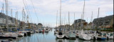
Port-en-Bessin, a small harbor, is used by fishing vessels and pleasure craft. Tides rise about 7.2m at springs and 5.9m at neaps. The harbor consists of an outer and inner avant-port, and two narrow wet basins. The avant-port dries 2 to 4m and is protected by a breakwaters. Entry to the wet basins is provided by a passage, 10.5m wide, with a gate. These basins are accessible to small vessels with drafts up to 4.2m at springs and 2.6m at neaps. The harbor may be contacted by VHF. The approach channel is indicated by a lighted range. With strong onshore winds, entry is not advised as a dangerous swell occurs in the outer avant-port. A prominent signal station is situated 0.5 mile W of the harbor. A conspicuous water tower stands about 1.8 miles ESE of the harbor. The prominent spires of Bayeux Cathedral, standing inland 5 miles SSE of Port-en-Bessin, may be seen from seaward.
2012/05/7
Update
Geof
La zone d'échouage (asséchant de 2 à 4 m) est équipée de 70 bouées de corps-morts, occupés pour une bonne part par les bateaux locaux. Pour accéder au bassin à flot qui accueille 6 visiteurs au maximum, il faut passer l'écluse, ouverte 2h avant et 2h après la PM. Accès au 1er bassin à droite en entrant.
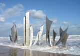
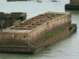
Arromanches-les-Bains is situated 5 miles E of Port-en-Bessin. A conspicuous statue of the Virgin Mary stands on the crest of a hill close E of this village. The caissons and wrecks of Port Winston, a former artificial harbor used for the Allied landings during WWII, front the ...
Omaha Beach, was the code name for one of the five sectors of the Allied invasion of German-occupied France in the Normandy landings on June 6, 1944, during World War II.
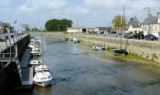
Courseulles-sur-Mer is a small harbor lying at the mouth of the Riviere Seulles. It is used by small fishing vessels and pleasure craft. The harbor consists of an avant-port leading to a wet dock and a tidal basin. The approach channel is indicated by a lighted range and dries 3.5m. ...
Grandcamp-Maisy, a small harbor, lies 1.5 miles E of Pointe de Maisy and 4.5 miles W of Pointe de la Percee. It is used by fishing vessels and yachts. The approach channel is indicated by a lighted range. The entrance channel has a minimum width of 18m and dries 2m. The entrance is ...
Isigny a small drying port, lies 1.5 miles inland on the Aure River. It is used by small coasters, fishing vessels, and pleasure craft. Passe d’Isigny, the entrance channel, is indicated by a lighted range and marked by buoys and beacons. The inner part of this channel leads ...
Rade de la Capelle, a roadstead lying between Banc du Cardonnet and Baie du Grand Vey, provides anchorage sheltered from S and SW winds, in a depth of 12m, mud and sand, good holding ground. Care is necessary to avoid several dangerous wrecks lying in this vicinity.


 VHF 18
 26 T
26 T


 Port-en-Bessin, a small harbor, is used by fishing vessels and pleasure craft. Tides rise about 7.2m at springs and 5.9m at neaps.
 La zone d'échouage (asséchant de 2 à 4 m) est équipée de 70 bouées de corps-morts, occupés pour une bonne part par les bateaux locaux. Pour accéder au bassin à flot qui accueille 6 visiteurs au maximum, il faut passer l'écluse, ouverte 2h avant et 2h après la PM. Accès au 1er bassin à droite en entrant.