Grandcamp - Maisy

Grandcamp - Maisy

To precisely geolocate this site. Update if necessary.

Localisation

Grandcamp - Maisy
LatitudeLongitude
DMS------
DM------
DD------

Characteristics

Port
VHF Canal
Water
Slip
Shower
Wifi
WC
Laundry

Description

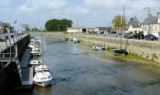
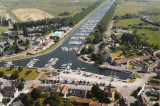
Grandcamp-Maisy, a small harbor, lies 1.5 miles E of Pointe de Maisy and 4.5 miles W of Pointe de la Percee. It is used by fishing vessels and yachts. The approach channel is indicated by a lighted range. The entrance channel has a minimum width of 18m and dries 2m. The entrance is protected by breakwaters and submerged seawalls. The wet basin is entered through a gated passage, 14.3m wide, and has a depth of 2m.
A light is shown from a mast, 12m high, standing in the town close S of the wet basin. A conspicuous water tower stands on the higher land about 2 miles SSW of the harbor. A prominent bell tower, 67m high, is situated on the high land backing the town.
2012/05/7
Update
Geof
Ebook

Manche - English Channel

  • 240 sites
  • 186 photos
  • publication date: 7 Jul 2023
  • .pdf file size: 229 Mb

Information


Grandcamp est un village tranquille du Bessin, en Normandie, dans le Calvados, et un port de pêche actif, situé entre les plages du Débarquement, Omaha Beach et Utah Beach. Réputé pour ses coquilles Saint-Jacques et ses poissons frais, on y pêche aussi la crevette dans les rochers découverts à marée basse, et on y cultive les huitres.

Proche de la Pointe du Hoc, Grandcamp a été adopté par les Rangers après la deuxième guerre mondiale comme leur " home away from home".

Nombre de places : 248 à flot dont 15 places visiteurs
Longueur : 12 m
Tirant d'eau : 1,80/2 m
Accès au bassin
Jour et nuit, 2h30 avant et après la pleine mer.

Accueil
Ouverture de 6 h à 22 h du 01/07 au 15/09 et de 8 h à 16 h le reste de l'année.

Services techniques
Eau à partir du ponton
Borne électrique à partir du ponton
Toilettes : 10
Douches : 7
Laverie à proximité
Station service à proximité
Rampe de mise à l'eau
Ponton d'attente : 15 places
Mécanicien à proximité
Grue : 8 tonnes
Zone de carénage
Surface technique d'hivernage à terre

Capitainerie
Tél. 02 31 22 63 16 - Fax 02 31 21 42 32 ou 02 31 22 99 95 (Mairie) - VHF Canal 9
2012/05/7
Update
Geof
Share your comments or photos on "Grandcamp - Maisy"

Sites around Grandcamp - Maisy

Flying distances - Direct line

Rade de la Capelle

2.6nm
285°
Rade de la Capelle, a roadstead lying between Banc du Cardonnet and Baie du Grand Vey, provides anchorage sheltered from S and SW winds, in a depth of 12m, mud and sand, good holding ground. Care is necessary to avoid several dangerous wrecks lying in this vicinity.
7 May 12
Geof

Isigny sur Mer

4.5nm
208°
Isigny a small drying port, lies 1.5 miles inland on the Aure River. It is used by small coasters, fishing vessels, and pleasure craft. Passe d’Isigny, the entrance channel, is indicated by a lighted range and marked by buoys and beacons.
The inner part of this channel leads ...
7 May 12
Geof

Omaha beach

6.6nm
99°
Omaha Beach, was the code name for one of the five sectors of the Allied invasion of German-occupied France in the Normandy landings on June 6, 1944, during World War II. 
6 Jun 19
azerty

Îles Saint-Marcouf

7.5nm
328°
The islands are directly administered by the French government, and form a protected nature reserve with restricted access. Mooring is allowed between the 2 islands.
A light is shown from a square tower, 17m high, standing on Ile du Large, the NE island. Ile de Terre, lying 0.3 ...
7 May 12
Geof

Carentan

8.7nm
237°
On one of the most varied coast of La Manche, Port Carentan offers "you" an execptional site. The basin, suprounded by grass and trees, blends perfectly into the town.
The acces to Port Carentan, is through one of the most beautiful parts of "Parc Naturel des Marais du Cotentin".
Port ...
25 Nov 07

Port en Bessin

11nm
101°
Port-en-Bessin, a small harbor, is used by fishing vessels and pleasure craft. Tides rise about 7.2m at springs and 5.9m at neaps.
The harbor consists of an outer and inner avant-port, and two narrow wet basins. The avant-port dries 2 to 4m and is protected by a  breakwaters. ...
7 May 12
Geof