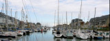
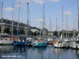
Arromanches-les-Bains is situated 5 miles E of Port-en-Bessin. A conspicuous statue of the Virgin Mary stands on the crest of a hill close E of this village. The caissons and wrecks of Port Winston, a former artificial harbor used for the Allied landings during WWII, front the town and extend up to about 1 mile offshore. Plateau du Calvados fronts the coast between the valley of Arromanches-les-Bains and Ouistreham, 15 miles ESE. This rocky bank has depths of less than 5m and extends up to about 2 miles offshore in places.
2012/05/7
Update
Geof
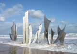
Port Winston - Port Mulberry B
Le Port Mulberry était un port artificiel construit sur la côte normande pendant la Seconde Guerre mondiale pour permettre l'approvisionnement des armées alliées dans les jours qui suivirent le débarquement de Normandie. En fait, deux ports furent assemblés au large des plages du Calvados, mais seul celui d'Arromanches sera opérationnel, le second devant Omaha Beach étant détruit par une tempête le 19 juin 1944.
2012/05/7
Update
Geof
Share your comments or photos on "Port Winston - Arromanches"
Port-en-Bessin, a small harbor, is used by fishing vessels and pleasure craft. Tides rise about 7.2m at springs and 5.9m at neaps. The harbor consists of an outer and inner avant-port, and two narrow wet basins. The avant-port dries 2 to 4m and is protected by a breakwaters. ...
Courseulles-sur-Mer is a small harbor lying at the mouth of the Riviere Seulles. It is used by small fishing vessels and pleasure craft. The harbor consists of an avant-port leading to a wet dock and a tidal basin. The approach channel is indicated by a lighted range and dries 3.5m. ...
Omaha Beach, was the code name for one of the five sectors of the Allied invasion of German-occupied France in the Normandy landings on June 6, 1944, during World War II.
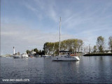
Ouistreham Marina, located at the heart of the Seine Bay and nearby the D-Daylanding beaches, is a port about 650 berths placed along the maritime canal from Caen to the Channel. Benefiting from the infrastructures of the merchant port, its access is reliable and secured. Within a ...
Grandcamp-Maisy, a small harbor, lies 1.5 miles E of Pointe de Maisy and 4.5 miles W of Pointe de la Percee. It is used by fishing vessels and yachts. The approach channel is indicated by a lighted range. The entrance channel has a minimum width of 18m and dries 2m. The entrance is ...


 Arromanches-les-Bains is situated 5 miles E of Port-en-Bessin. A conspicuous statue of the Virgin