Omaha Beach, was the code name for one of the five sectors of the Allied invasion of German-occupied France in the Normandy landings on June 6, 1944, during World War II.
2019/06/6
Update
azerty
"Omaha Beach" est l'une des 5 plages du débarquement le 6 Juin 1944.
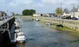
Port-en-Bessin, a small harbor, is used by fishing vessels and pleasure craft. Tides rise about 7.2m at springs and 5.9m at neaps. The harbor consists of an outer and inner avant-port, and two narrow wet basins. The avant-port dries 2 to 4m and is protected by a breakwaters. ...
Grandcamp-Maisy, a small harbor, lies 1.5 miles E of Pointe de Maisy and 4.5 miles W of Pointe de la Percee. It is used by fishing vessels and yachts. The approach channel is indicated by a lighted range. The entrance channel has a minimum width of 18m and dries 2m. The entrance is ...
Rade de la Capelle, a roadstead lying between Banc du Cardonnet and Baie du Grand Vey, provides anchorage sheltered from S and SW winds, in a depth of 12m, mud and sand, good holding ground. Care is necessary to avoid several dangerous wrecks lying in this vicinity.
Isigny a small drying port, lies 1.5 miles inland on the Aure River. It is used by small coasters, fishing vessels, and pleasure craft. Passe d’Isigny, the entrance channel, is indicated by a lighted range and marked by buoys and beacons. The inner part of this channel leads ...
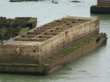
Arromanches-les-Bains is situated 5 miles E of Port-en-Bessin. A conspicuous statue of the Virgin Mary stands on the crest of a hill close E of this village. The caissons and wrecks of Port Winston, a former artificial harbor used for the Allied landings during WWII, front the ...
The islands are directly administered by the French government, and form a protected nature reserve with restricted access. Mooring is allowed between the 2 islands.
A light is shown from a square tower, 17m high, standing on Ile du Large, the NE island. Ile de Terre, lying 0.3 ...


 Omaha Beach, was the code name for one of the five sectors of the Allied invasion of German-occupied France in the Normandy landings on June 6, 1944, during World War II.
  "Omaha Beach" est l'une des 5 plages du débarquement le 6 Juin 1944.
 Monument Signal