La zone d'échouage (asséchant de 2 à 4 m) est équipée de 70 bouées de corps-morts, occupés pour une bonne part par les bateaux locaux. Pour accéder au bassin à flot qui accueille 6 visiteurs au maximum, il faut passer l'écluse, ouverte 2h avant et 2h après la PM. Accès au 1er bassin à droite en entrant.
Port-en-Bessin, a small harbor, is used by fishing vessels and pleasure craft. Tides rise about 7.2m at springs and 5.9m at neaps. The harbor consists of an outer and inner avant-port, and two narrow wet basins. The avant-port dries 2 to 4m and is protected by a breakwaters. Entry to the wet basins is provided by a passage, 10.5m wide, with a gate. These basins are accessible to small vessels with drafts up to 4.2m at springs and 2.6m at neaps. The harbor may be contacted by VHF. The approach channel is indicated by a lighted range. With strong onshore winds, entry is not advised as a dangerous swell occurs in the outer avant-port. A prominent signal station is situated 0.5 mile W of the harbor. A conspicuous water tower stands about 1.8 miles ESE of the harbor. The prominent spires of Bayeux Cathedral, standing inland 5 miles SSE of Port-en-Bessin, may be seen from seaward.
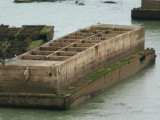
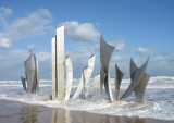
Port Winston - Port Mulberry B Le Port Mulberry était un port artificiel construit sur la côte normande pendant la Seconde Guerre mondiale pour permettre l'approvisionnement des armées alliées dans les jours qui suivirent le débarquement de Normandie. En fait, deux ports furent ...
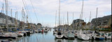
Nombre de places : 750 à flot en 2 bassins dont 25 places visiteurs. Pontons d'échouage sur la Seulles
Bassin Joinville : longueur 12 m - tirant d'eau 2,5 m
Bassin Ile de Plaisance : longueur 8 m - tirant d'eau 1,5 m
Accès au bassinBassin
Joinville : 2 h avant et ...
Information Grandcamp est un village tranquille du Bessin, en Normandie, dans le Calvados, et un port de pêche actif, situé entre les plages du Débarquement, Omaha Beach et Utah Beach. Réputé pour ses coquilles Saint-Jacques et ses poissons frais, on y pêche aussi la crevette ...
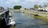
Nombre de places : 45 sur pontons d'échouage dont 5 places visiteurs
Longueur : tout gabarit
Tirant d'eau : entre 0 et 6 mAccès au bassinPar la Vire, 3 h avant et après la pleine mer. Zone marnante.AccueilServices Techniques - Mairie : ouvert du lundi au vendredi de ...
Rade de la Capelle, a roadstead lying between Banc du Cardonnet and Baie du Grand Vey, provides anchorage sheltered from S and SW winds, in a depth of 12m, mud and sand, good holding ground. Care is necessary to avoid several dangerous wrecks lying in this vicinity.


 VHF 18
 26 T
26 T