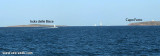
Passo delle Bisce leads between Capo Ferro and Isola delle Bisce.
It is free of dangers but it is better stay away from the east side of the island, for a series submerged rocks and shoals. You can instead bring with ease from the side of Sardinia. It is used by ships that carry from E Rada of Santa Stefano.
The passage is marked at night by two lights: the light of the Bisce, flashes green, the lamp of Ferro cape, located 300 meters from the lighthouse, flashes red.
2012/09/13
Update
Joëlle
Passo delle Bisce (Sardegna)
2012-09-13
Update
Joëlle
La passe delle Bisce s'étend entre le Cap Ferro et l'île delle Bisce.
Il n'y a aucun danger mais il vaut mieux se tenir au large du bord E de l'île, à cause d'un groupe de rochers submergés et de haut-fonds. Vous pouvez plutôt naviguer aisément du côté de la Sardaigne. La passe est utilisée par les vaisseaux venant de l'E se dirigeant vers la rade de Santa Stefano.
Le passage est marqué dans la nuit par deux feux: le feu de la Bisce, qui clignote en vert, le feu de cap Ferro, situé à 300 mètres du phare, qui clignote en rouge.
2012/09/13
Update
Joëlle
Passo delle Bisce, Largo più di mezzo chilometro, conduce tra Capo Ferro e l'Isola delle Bisce.
E 'privato di pericoli, meglio mantenersi distanti dal lato SE dell’isola, per una serie si scogli sommersi e secche.Ci si può invece avvicinare con disinvoltura dal lato della Sardegna. E utilizzato da navi dal E che procedono a Rada di Santa Stefano.
Il passaggio è delimitato di notte da due
fanali: il fanale delle Bisce, lampi verdi, il fanale di capo Ferro, posto a 300 metri dal faro, lampi rossi.
It is the largest island of the archipelago composed of sixty islets and 7 major islands, in the NE end tip of Sardinia. It is mountainous and arid. This is the only inhabited island thoroughly. It is connected by a bridge to Caprera island where are the house and the tomb of Garibaldi. ...
Gulf of Arzachena (Arsachena), located between Punta Saline and Tre Monti Cape, is a high inlet whose banks are lined with shoals. S tip, Arzachena, W of the entrance, a beacon consists of an iron post with a sheer spherical white marks a rock particularly ...
Tavolara island is a limestone massif 6 kilometres long and 500 m wide, and 565 m high.The overhanging cliffs make it inaccessible, with the exception of a bay and a beach that is located at each end of the island, Spalmatore di Fuori northeast (military zone) and Spalmatore di Terra ...
Degli Aranci gulf is is bounded, on the N, by the peninsula of which Capo Figari is the E extremity.This gulf is sheltered from NE and NW winds. Strong SE winds send in a heavy sea and storms from the N and E cause a considerable swell in the gulf. During offshore winds, which are ...
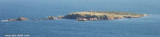
Isola delle Bisce, 21m high and barren, lies close N of Capo Ferro. This islet is not easily distinguishable from the land behind it.It is surrounded by shoals and flush rocks. A lighthouse stands on a tower 9 m high, on the S side of the island. On the N side of the rocky ...
NE Arzachena gulf, N Porto Cervo, Capo Ferro is the NE end of the Sardinia. It is not on the seaside, but a little bit in the inside over an hill. It is 18 m high on a promontory, south of the Isola delle Biscie.


 Passo delle Bisce leads between Capo Ferro and Isola delle Bisce.
")
 La passe delle Bisce s'étend entre le Cap Ferro et l'île delle Bisce.
 Passo delle Bisce, Largo più di mezzo chilometro, conduce tra Capo Ferro e l'Isola delle Bisce.