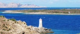
Isola La Maddalena (Arcipelago della Maddalena)
6.6nm
308°
It is connected by a bridge to Caprera island where are the house and the tomb of Garibaldi. ...
26 Nov 12
Joëlle
| Latitude | Longitude | |
| DMS | --- | --- |
| DM | --- | --- |
| DD | --- | --- |


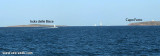
 Isola delle Bisce, 21m high and barren, lies close N of Capo Ferro.
This islet is not easily distinguishable from the land behind it.
It is surrounded by shoals and flush rocks.
A lighthouse stands on a tower 9 m high, on the S side of the island. On the N side of the rocky shoals smelling extend up to about 0.4 MN to N.
It is also part of the International Park of Bonifacio.
It has a small beach on the S side, but it should be approached with caution and cards in hand. The beach often collects waste transported by sea
A 1 MN NE of the island is the secca delle Bisce, 4 m above the sea level, paradise for divers.
")
 Isole delle Bisce, haute de 21 m et stérile, se trouve à proximité et au N de Capo Ferro.
Cet îlot n'est pas facile à distinguer du continent qui se trouve derrière lui.
Il est entouré de hauts-fonds et et de rochers affleurants.
Il fait également parti du Parc International des Bouches de Bonifacio.
Il possède une petite plage sur le côté S, mais il faut l'aborder avec prudence et carte en main. La plage recueille souvent les déchets transportés par la mer.
A 1 MN au NE de l'île se trouve la secca delle Bisce, à 4 m au-dessus du niveau de la mer, véritable paradis pour les plongeurs.
 Isola delle Bisce, 21m alta e sterile, si trova vicino a N di Capo Ferro.
Questo isolotto non è facilmente distinguibile dalla terra dietro di esso.
L’isola è circondata da bassi fondali e secche affioranti.
Una luce è mostrata da una torre alta, 9m, si trova sul lato S dell'isolotto. Il lato N dei isolotti fallo e rocciosa si estendono fino a circa 0,4 km a N di esso.
E 'anche parte del Parco Internazionale Bocche di Bonifacio.
L’unica spiaggetta si trova sul lato meridionale dell’isola ma occorre avvicinarsi con cautela e carte alla mano. La spiaggia raccoglie spesso i rifiuti trasportati dal mare ed è poco battuta. Un miglio a NE dell’isola si trova la Secca delle Bisce, 4 metri sul livello del mare, vero e proprio paradiso per i subacquei.
Ebook | Sardegna North East
|
Ebook | Sardegna
|