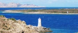
NE Arzachena gulf, N Porto Cervo, Capo Ferro is the NE end of the Sardinia.
It is not on the seaside, but a little bit in the inside over an hill. It is 18 m high on a promontory, south of the Isola delle Biscie.
2012/09/10
Update
Joëlle
cala coticcio
2016/09/8
Update
Au NE du golfe d'Arzachena, au N de Porto Cervo, le cap Ferro est l'extrémité NE de la Sardaigne.
Le phare de 18 m de haut se trouve sur un promontoire au S de l'île des Biscie.
2012/09/10
Update
Joëlle
NE Golfo di Arzachena, a N di Porto Cervo, Capo Ferro è la punta NE della Sardegna.Uno faro di 18 metri di altezza è situato su un promontorio dell'isola di S Biscie.
It is the largest island of the archipelago composed of sixty islets and 7 major islands, in the NE end tip of Sardinia. It is mountainous and arid. This is the only inhabited island thoroughly. It is connected by a bridge to Caprera island where are the house and the tomb of Garibaldi. ...
Gulf of Arzachena (Arsachena), located between Punta Saline and Tre Monti Cape, is a high inlet whose banks are lined with shoals. S tip, Arzachena, W of the entrance, a beacon consists of an iron post with a sheer spherical white marks a rock particularly ...
Tavolara island is a limestone massif 6 kilometres long and 500 m wide, and 565 m high.The overhanging cliffs make it inaccessible, with the exception of a bay and a beach that is located at each end of the island, Spalmatore di Fuori northeast (military zone) and Spalmatore di Terra ...
Degli Aranci gulf is is bounded, on the N, by the peninsula of which Capo Figari is the E extremity.This gulf is sheltered from NE and NW winds. Strong SE winds send in a heavy sea and storms from the N and E cause a considerable swell in the gulf. During offshore winds, which are ...
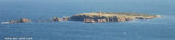
Isola delle Bisce, 21m high and barren, lies close N of Capo Ferro. This islet is not easily distinguishable from the land behind it.It is surrounded by shoals and flush rocks. A lighthouse stands on a tower 9 m high, on the S side of the island. On the N side of the rocky ...
Passo delle Bisce leads between Capo Ferro and Isola delle Bisce. It is free of dangers but it is better stay away from the east side of the island, for a series submerged rocks and shoals. You can instead bring with ease from the side of Sardinia. It is used by ships that carry ...


 NE Arzachena gulf, N Porto Cervo, Capo Ferro is the NE end of the Sardinia.
  Au NE du golfe d'Arzachena, au N de Porto Cervo, le cap Ferro est l'extrémité NE de la Sardaigne.
 NE Golfo di Arzachena, a N di Porto Cervo, Capo Ferro è la punta NE della Sardegna.Uno faro di 18 metri di altezza è situato su un promontorio dell'isola di S Biscie.
")
")