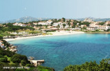
Dell'Orso marina is a fjord located between Di Liscia di Vacca bay and Sardinia Bay, in front of Caprera island and Capuccini islet. The marina has some cement piers.
T. 99477/99475
F. 99468
M. polquatu@tin.it
410 b. (<35 m)
2012/09/11
Update
Joëlle
La marina dell'Orsu de Poltu Quatu est située dans un fjord naturel entre Liscia di Vacca et cala Battistone (ou Baia Sardinia), en face de l'île Caprera et de l'îlot des Cappuccini. La marina est constituée de plusieurs pontons en ciment.
T. 99477/99475
F. 99468
M. polquatu@tin.it
410 pl. (<35 m)
2012/09/10
Update
Joëlle
Marina dell'Orso di Poltu Quatu è un fiordo situato tra la baia di Liscia di Vacca e Baia Sardinia, di fronte all'isola di Caprera e all'isolotto dei Cappuccini. La marina dispone di alcuni pontili cemento.
Gulf of Arzachena (Arsachena), located between Punta Saline and Tre Monti Cape, is a high inlet whose banks are lined with shoals. S tip, Arzachena, W of the entrance, a beacon consists of an iron post with a sheer spherical white marks a rock particularly ...
It is the largest island of the archipelago composed of sixty islets and 7 major islands, in the NE end tip of Sardinia. It is mountainous and arid. This is the only inhabited island thoroughly. It is connected by a bridge to Caprera island where are the house and the tomb of Garibaldi. ...
Tavolara island is a limestone massif 6 kilometres long and 500 m wide, and 565 m high.The overhanging cliffs make it inaccessible, with the exception of a bay and a beach that is located at each end of the island, Spalmatore di Fuori northeast (military zone) and Spalmatore di Terra ...
Degli Aranci gulf is is bounded, on the N, by the peninsula of which Capo Figari is the E extremity.This gulf is sheltered from NE and NW winds. Strong SE winds send in a heavy sea and storms from the N and E cause a considerable swell in the gulf. During offshore winds, which are ...
Located E of Cape Tre Monti, just before Battistone cape. Sardinia Bay or cala di Battistone has a military mole in the center that allows docking twenty boats and anchoragio during the day.
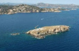
L 'isola dei Cappuccini is a small island, located less than 500 meters from the northeast coast of Sardinia.It takes its name from the convent of Capuchin Friars, today abandoned, which stands on the highest part of the island.
Park is part of International Straits of Bonifacio, ...


 canal 9, 16


 (Sardegna)")
 (Sardegna)")
 Dell'Orso marina is a fjord located between Di Liscia di Vacca bay and Sardinia Bay, in front of Caprera island and Capuccini islet. The marina has some cement piers.
 La marina dell'Orsu de Poltu Quatu est située dans un fjord naturel entre Liscia di Vacca et cala Battistone (ou Baia Sardinia), en face de l'île Caprera et de l'îlot des Cappuccini. La marina est constituée de plusieurs pontons en ciment.
  Marina dell'Orso di Poltu Quatu è un fiordo situato tra la baia di Liscia di Vacca e Baia Sardinia, di fronte all'isola di Caprera e all'isolotto dei Cappuccini. La marina dispone di alcuni pontili cemento.
  (Sardegna)")
 (Sardegna)")