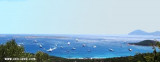
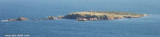
L 'isola dei Cappuccini is a small island, located less than 500 meters from the northeast coast of Sardinia.
It takes its name from the convent of Capuchin Friars, today abandoned, which stands on the highest part of the island.
Park is part of International Straits of Bonifacio, but unlike the other islands has some facilities, a small marina and a few bungalows which are rented to wealthy tourists who can enjoy tranquility and absolute discretion.
2012/09/12
Update
Joëlle
Isola dei Cappucini (Arzachena Sardegna)
2012-09-12
Update
Joëlle
L 'isola dei Cappuccini est une petite île, située à moins de 500 mètres de la côte nord de la Sardaigne.
Elle tire son nom du couvent des Frères Capucins, aujourd'hui, abandonnés, qui se dresse sur la partie haute de l'île.
Elle fait partie du Parc international du détroit de Bonifacio, mais à la différence des autres îles de certaines installations, une petite marina et à quelques bungalows qui sont loués aux riches touristes qui peuvent profiter de la tranquillité et la discrétion absolue.
2012/09/12
Update
Joëlle
Isola dei Cappucini (Arzachena Sardegna)
2012-09-12
Update
Joëlle
L'isola dei Cappuccini è un isolotto di quasi 3000 m2 situato a meno di 500 metri a nord-ovest della penisola della Costa Smeralda in Gallura, nella costa nord-orientale della Sardegna.
L'isola è cosi chiamata per via del convento dei Frati Cappuccini, oggi abbandonato, che sorge sulla parte più alta dell’isola.
Fa parte del Parco Internazionale delle Bocche di Bonifacio, ma diversamente dalle altre isole presenta alcune strutture ricettive, possiede un piccolo porticciolo per l'approdo delle barche.
It is the largest island of the archipelago composed of sixty islets and 7 major islands, in the NE end tip of Sardinia. It is mountainous and arid. This is the only inhabited island thoroughly. It is connected by a bridge to Caprera island where are the house and the tomb of Garibaldi. ...
Gulf of Arzachena (Arsachena), located between Punta Saline and Tre Monti Cape, is a high inlet whose banks are lined with shoals. S tip, Arzachena, W of the entrance, a beacon consists of an iron post with a sheer spherical white marks a rock particularly ...
Tavolara island is a limestone massif 6 kilometres long and 500 m wide, and 565 m high.The overhanging cliffs make it inaccessible, with the exception of a bay and a beach that is located at each end of the island, Spalmatore di Fuori northeast (military zone) and Spalmatore di Terra ...
Degli Aranci gulf is is bounded, on the N, by the peninsula of which Capo Figari is the E extremity.This gulf is sheltered from NE and NW winds. Strong SE winds send in a heavy sea and storms from the N and E cause a considerable swell in the gulf. During offshore winds, which are ...
There is a small pontoon 50 m long, which may be used only by small boats (TE: 2-4 m). Anchor in 5-10m, protected from SW winds, but open to N and NE winds. Swell returns there. The banks are lined by rocks submerged and emergent, approach with caution.
Isola delle Bisce, 21m high and barren, lies close N of Capo Ferro. This islet is not easily distinguishable from the land behind it.It is surrounded by shoals and flush rocks. A lighthouse stands on a tower 9 m high, on the S side of the island. On the N side of the rocky ...


 L 'isola dei Cappuccini is a small island, located less than 500 meters from the northeast coast of Sardinia.
")
 L 'isola dei Cappuccini est une petite île, située à moins de 500 mètres de la côte nord de la Sardaigne.
")
 L'isola dei Cappuccini è un isolotto di quasi 3000 m2 situato a meno di 500 metri a nord-ovest della penisola della Costa Smeralda in Gallura, nella costa nord-orientale della Sardegna.