Cala di Battistone (o Baia Sardinia Sardegna)

Cala di Battistone (o Baia Sardinia Sardegna)

To precisely geolocate this site. Update if necessary.

Localisation

Cala di Battistone (o Baia Sardinia Sardegna)
LatitudeLongitude
DMS------
DM------
DD------

Characteristics

Mooring
Sand
Restaurant
Beach
Sand
Rock
Parasol

Description

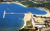
Located E of Cape Tre Monti, just before Battistone cape.

Sardinia Bay or cala di Battistone has a military mole in the center that allows docking twenty boats and anchoragio during the day.

This bay is not very well protected.

Anchor in 1.5 to 3 m deep.
2012/09/8
Update
Joëlle
Située à l'E du cap Tre Monti, juste avant le cap Battistone. 

La baie Sardinia ou cala di Battistone a un mole militaire au centre qui permet l'amarrage d'une vingtaine de bateaux et le mouillage pendant la journée.

Cette rade n'est pas très bien abritée.

On mouille dans 1,5 à 3 m de fond.
2012/09/8
Update
Joëlle
Situata all'E del capo di Tre Monti, prima il capo Battistone.
2012/09/8
Update
Joëlle
Situata all'E di Capo Tre Monti, poco prima il capo Battistone.
Baia Sardinia o cala di Battistone ha uno molo militare al centro che permette l'ormeggio di circa venti imbarcazioni e l’ancoraggio diurno. 

Questa baia non è molto ben protetto.

Si ancora in 1.5 a 3 m di profondità.
2012/09/8
Update
Joëlle
Cala di Battistone (o Baia Sardinia Sardegna)
2012-09-08
Update
Joëlle
Cala di Battistone (o Baia Sardinia Sardegna)
2012-09-08
Update
Joëlle
Cala di Battistone (o Baia Sardinia Sardegna)
2012-09-08
Update
Joëlle
Ebook

Sardegna North East

  • 156 sites
  • 349 photos
  • publication date: 11 Jul 2023
  • .pdf file size: 66 Mb
Share your comments or photos on "Cala di Battistone (o Baia Sardinia Sardegna)"

Sites around Cala di Battistone (o Baia Sardinia Sardegna)

Flying distances - Direct line

Golfo Di Arzachena (Sardegna)

1.3nm
241°
Gulf of Arzachena (Arsachena), located between Punta Saline and Tre Monti Cape, is a high inlet whose banks are lined with shoals.
S tip, Arzachena, W of the entrance, a beacon consists of an iron post with a sheer spherical white marks a rock particularly ...
8 Sep 12
Joëlle

Isola La Maddalena (Arcipelago della Maddalena)

6.4nm
329°
It is the largest island of the archipelago composed of sixty islets and 7 major islands, in the NE end tip of Sardinia. It is mountainous and arid. This is the only inhabited island thoroughly.
It is connected by a bridge to Caprera island where are the house and the tomb of Garibaldi. ...
26 Nov 12
Joëlle

Isola Tavolara (Sardegna)

17nm
143°
Tavolara island is a limestone massif 6 kilometres long and 500 m wide, and 565 m high.The overhanging cliffs make it inaccessible, with the exception of a bay and a beach that is located at each end of the island, Spalmatore di Fuori northeast (military zone) and Spalmatore di Terra ...
7 May 14
Joëlle

Golfo degli Aranci (Sardegna)

11nm
144°
Degli Aranci gulf is is bounded, on the N, by the peninsula of which Capo Figari is the E extremity.This gulf is sheltered from NE and NW winds. Strong SE winds send in a heavy sea and storms from the N and E cause a considerable swell in the gulf. During offshore winds, which are ...
28 Sep 12
Joëlle

Marina dell'Orso (Poltu Quatu) (Sardegna)

0.7nm
106°
Dell'Orso marina is a fjord located between Di Liscia di Vacca bay and Sardinia Bay, in front of Caprera island and Capuccini islet. The marina has some cement piers.

T. 99477/99475F. 99468M. polquatu@tin.it410 b. (<35 m)
11 Sep 12
Joëlle

Cala Bitta (Sardegna)

1nm
208°
Beautiful small rocky bay with a granite dock that dates to the nineteenth century. The cove is sheltered by the island of "Mucchi Bainchi." Small harbor, Harbor, no more than 2m draft. Anchorage possible in the bay to the north.Tel. (+39) 78 99 92 43
F. (+39) 78 ...
8 Sep 12
Joëlle