There is a small pontoon 50 m long, which may be used only by small boats (TE: 2-4 m). Anchor in 5-10m, protected from SW winds, but open to N and NE winds. Swell returns there. The banks are lined by rocks submerged and emergent, approach with caution.
2012/09/11
Update
Joëlle
Il existe un petit ponton long de 50 m qui ne peut servir qu'aux petites embarcations (TE: 2 à 4 m). Mouillage dans 5-10m, protégé des vents de SW, mais ouvert aux vents de N et NE. La houle y rentre. Les rives sont bordées par des roches immergées et émergées, s'approcher avec prudence.
2012/09/11
Update
Joëlle
C'è un piccolo pontile lungo 50 m, che può essere utilizzato solo dalle piccole imbarcazioni (TE: 2-4 m). Ancoraggio per 5-10m e protetto dai venti da SW, ma aperto a quelle del N e NE. Onda vi ritorni. Le rive sono fiancheggiate da rocce sommerse e emergente, approccio con prudenza.
It is the largest island of the archipelago composed of sixty islets and 7 major islands, in the NE end tip of Sardinia. It is mountainous and arid. This is the only inhabited island thoroughly. It is connected by a bridge to Caprera island where are the house and the tomb of Garibaldi. ...
Gulf of Arzachena (Arsachena), located between Punta Saline and Tre Monti Cape, is a high inlet whose banks are lined with shoals. S tip, Arzachena, W of the entrance, a beacon consists of an iron post with a sheer spherical white marks a rock particularly ...
Tavolara island is a limestone massif 6 kilometres long and 500 m wide, and 565 m high.The overhanging cliffs make it inaccessible, with the exception of a bay and a beach that is located at each end of the island, Spalmatore di Fuori northeast (military zone) and Spalmatore di Terra ...
Degli Aranci gulf is is bounded, on the N, by the peninsula of which Capo Figari is the E extremity.This gulf is sheltered from NE and NW winds. Strong SE winds send in a heavy sea and storms from the N and E cause a considerable swell in the gulf. During offshore winds, which are ...
L 'isola dei Cappuccini is a small island, located less than 500 meters from the northeast coast of Sardinia.It takes its name from the convent of Capuchin Friars, today abandoned, which stands on the highest part of the island.
Park is part of International Straits of Bonifacio, ...
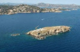
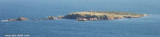
Isola delle Bisce, 21m high and barren, lies close N of Capo Ferro. This islet is not easily distinguishable from the land behind it.It is surrounded by shoals and flush rocks. A lighthouse stands on a tower 9 m high, on the S side of the island. On the N side of the rocky ...


 fontaine


 There is a small pontoon 50 m long, which may be used only by small boats (TE: 2-4 m).
 Il existe un petit ponton long de 50 m qui ne peut servir qu'aux petites embarcations (TE: 2 à 4 m).
 C'è un piccolo pontile lungo 50 m, che può essere utilizzato solo dalle piccole imbarcazioni (TE: 2-4 m).
")
")
")