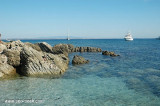
Area Marina Protetta di Capo Caccia - I. Piana (Sardegna)
36nm
351°
20 Nov 12
Joëlle
| Latitude | Longitude | |
| DMS | --- | --- |
| DM | --- | --- |
| DD | --- | --- |


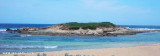
 AMPdel Sinis_I Mal di Ventre
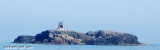
 Mal di Ventre island takes its name the difficulties encountered by sailors to navigate its waters.
Dangers lie SW until 1 NM and NE to 0,8 NM. NE extremity of them is marked by a beacon.
A prohibited area, best seen on the chart, extends from the NE extremity to the SW extremity enclosing the entire W part of the island.
")
 L'île Mal-de-Ventre doit son nom aux difficultés rencontrées par les navigateurs pour naviguer dans ses eaux.
Situé à l'opposé de la péninsule del Sunis, bas et plat, haut de 18 m, il a une surface de 80 hectares.
Il est protégé et porte un phare dans une cabane blanche.
Des dangers s'étendent jusqu'à 1 M au SW et 0,8 M au NE. L'extrémité NE de ces derniers est marquée par une balise.
Une zone interdite s'étend de l'extrémité NE de l'île vers l'extrémité SW englobant la totale partie W de l'île.
")
 L'isola Mal di Ventre deve il suo nome dalla difficile navigazione che si compie nelle sue acque.
 Situata di fronte alla penisola del Sinis, l'isola di Mal di Ventre, bassa e piatta, 18 m alta, si estende per una superficie di 80 ettari.
E' qualificata area marina protetta e ha uno faro in una casa bianca.
Pericoli si estendono fino a 1 MN al SW e 0,8 MN a NE. L'estremità NE di quest'ultimo è contrassegnato da un meda.
Una zona vietata si estende dalla fine NE dell'isola fino alla fine SW che comprende la parte totale W dell'isola.
Ebook | Sardegna West
|