Localisation
Capo Mannu (San Vero Milis Sardegna)
Latitude Longitude DMS --- --- DM --- --- DD --- ---
Description
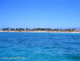
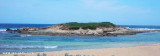
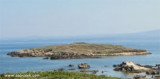
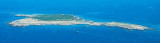
Mannu cape, 48 m high is steep with an irregular profile. It is the N starting point of the peninsula del Sinis.
When seen from the N or S, this cape appears to consist of two flat islets.
A light is shown from a structure, 11m high, standing on the cape.
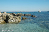
It's a surf spot.
Torre Mora to SW and Torre Mannu to NE stand close and 0.7 mile, respectively, of the light.
Le cap Mannu, haut de 48 m, est escarpé avec un profil irrégulier. Il constitue le point de départ N de la péninsule del Sinis.
Vu du N et du S il apparaît comme deux îlots.
Il porte un phare haut de 11 m.
C'est un spot de surf.
La tour Mora au SW et la tour Mannu au NE du phare s'élèvent respectivement à 0,7 MN de celui-ci.
Capo Mannu, 48 m alto, è ripida con un profilo irregolare. E 'il punto N di partenza della penisola del Sinis.
Visto dall N o S si presenta come due isole.
Ha un faro alto di 11 metri.
E' uno spot di surf.
La torre Mora al SW e la torre Mannu al NE dal faro sono, rispettivamente, 0,7 MN dello stesso.
Sa Mora tower
Sa Mora tower
torre Mannu
Ebook
Sardegna West 122 sites 310 photos publication date: 6 Aug 2024 .pdf file size: 61 Mb
Ebook
Sardegna 444 sites 1072 photos publication date: 6 Aug 2024 .pdf file size: 246 Mb
Share your comments or photos on "Capo Mannu (San Vero Milis Sardegna)"
Sites around Capo Mannu (San Vero Milis Sardegna)Flying distances - Direct line
Isola Mal-di-Ventre (Sardegna)
Area Marina Protetta di Capo Caccia - I. Piana (Sardegna)
Cala dei Pastori (I Mal di Ventre Sardegna)
Sea-Seek Sailing Guide During your navigation, remember to update the data. If a harbor, marina or anchorage is missing, create it. Thank you for all boaters.


 Mannu cape, 48 m high is steep with an irregular profile. It is the N starting point of the peninsula del Sinis.
 Le cap Mannu, haut de 48 m, est escarpé avec un profil irrégulier. Il constitue le point de départ N de la péninsule del Sinis.
 Capo Mannu, 48 m alto, è ripida con un profilo irregolare. E 'il punto N di partenza della penisola del Sinis.
")
")
") Sa Mora tower
Sa Mora tower") Sa Mora tower
Sa Mora tower") torre Mannu
torre Mannu