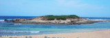
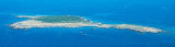
Mal di Ventre island takes its name the difficulties encountered by sailors to navigate its waters. Located opposite the Peninsula del Sunis, low and flat, 18 m high, it has an area of 80 hectares. A light is shown from a structure, 4m high, standing on the summit of the ...
The park begins at Capo Galera to continue toward the gulf of Porto Conte that is protected by two promontories, Punta Giglio and Capo Caccia-Monte Timidone. The marine protected area embraces the stretch of sea to the north-west of Punta Cristallo.Almost all of the park consists ...
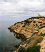
Mannu cape, 48 m high is steep with an irregular profile. It is the N starting point of the peninsula del Sinis. When seen from the N or S, this cape appears to consist of two flat islets.A light is shown from a structure, 11m high, standing on the cape.It's a surf spot. Torre ...


 Cala Saline, S capo Mannu, offers an ancorage, in 3/ 4 m, sheltered of NE and SE winds.
 Cala Saline, au S de capo Mannu, offre un mouillage, par 3 a 4 m, abrité des vents de NE et SE.
 Cala Saline, al S da capo Mannu, offre un ancoraggio, da 3/4 m, al riparo dei venti di NE e SE.
") La plage
La plage")
")
")