Cala dei Pastori (I Mal di Ventre Sardegna)

Cala dei Pastori (I Mal di Ventre Sardegna)

To precisely geolocate this site. Update if necessary.

Localisation

Characteristics

Grass
Rock
Mooring
Sand
Beach
Sand
Diving

Description

You can anchor in the samll cove, to 250 m from the shore, by 5 m, SE of the island.

Sheltered from NW winds.

Do not try to get closer because it is strewn with rocks, not even tighten the northern tip which is dangerous.

Be careful if you landwith tender, the island is the domain of birds, gulls are very aggressive!

2012/11/11
Update
On peut ancrer dans cette petite anse, à 250 m du rivage, par 5 m, au SE de l'île.

Abritée des vents NW.

Ne pas chercher à s'approcher plus près car c'est semé de cailloux, de même ne pas serrer la pointe nord qui est dangereuse.

Attention si vous débarquez en annexe, l'île est le domaine des oiseaux, les goélands sont très agressifs!

2012/11/11
Update
Si puo ancorare in questa piccola cala, a 250 m della riva, in 5 m, SE dall'isola.

Al riparo dai venti NW.

Non cercare di avvicinarsi perché è cosparso di ciottoli, nemmeno non stringere la punta settentrionale che è pericoloso.

Prestare attenzione se si sbarcano, l'isola è il dominio degli uccelli, gabbiani sono molto aggressivi!

2012/11/11
Update
Cala dei Pastori  (I Mal di Ventre  Sardegna)
2012-11-11
Update
Cala dei Pastori  (I Mal di Ventre  Sardegna)
2012-11-11
Update
Cala dei Pastori  (I Mal di Ventre  Sardegna)
2012-11-11
Update
Ebook

Sardegna West

  • 122 sites
  • 310 photos
  • publication date: 11 Jul 2023
  • .pdf file size: 59 Mb
Ebook

Sardegna

  • 444 sites
  • 1069 photos
  • publication date: 11 Jul 2023
  • .pdf file size: 243 Mb
Share your comments or photos on "Cala dei Pastori (I Mal di Ventre Sardegna)"

Sites around Cala dei Pastori (I Mal di Ventre Sardegna)

Flying distances - Direct line

Isola Mal-di-Ventre (Sardegna)

0.6nm
10°
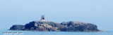
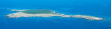
Mal di Ventre island takes its name the difficulties encountered by sailors to navigate its waters.
Located opposite the Peninsula del Sunis, low and flat, 18 m high, it has an area of ​​80 hectares.
A light is shown from a structure, 4m high, standing on the summit of the ...
11 Nov 12

Area Marina Protetta di Capo Caccia - I. Piana (Sardegna)

37nm
351°
The park begins at Capo Galera to continue toward the gulf of Porto Conte that is protected by two promontories, Punta Giglio and Capo Caccia-Monte Timidone. The marine protected area embraces the stretch of sea to the north-west of Punta Cristallo.Almost all of the park consists ...
20 Nov 12
Joëlle

Capo Mannu (San Vero Milis Sardegna)

4.6nm
49°
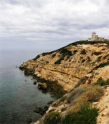
Mannu cape, 48 m high is steep with an irregular profile. It is the N starting point of the peninsula del Sinis.
When seen from the N or S, this cape appears to consist of two flat islets.A light is shown from a structure, 11m high, standing on the cape.It's a surf spot.
Torre ...
12 Nov 12
Joëlle

Scoglio Il Catalano (S Marco Sardegna)

6.3nm
193°
Il Catalano rock, 11 m high, is 7,5 NM WNW of San Marco cape.
It is dark-colored, surrounded of shoals and is surmonted by a disused light structure.Two shoals, with depths 2.5m and 8m, lie about 0.7 mile NNE and 2.5 miles NNE, respectively, of Il Catalano.
9 Nov 12

Isola Sa Mesalonga (Capo Mannu Sardegna)

5.6nm
48°
Sa Mesalonga island, that means "Long table" is a rocky platform which is located near the coast between Cape Mannu and Su Pallosu Point.
12 Nov 12
Joëlle