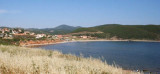
Oristano gulf is entered between Capo Frasca and Capo di San Marco, 5,5 NM , NNW. The gulf has low, sandy, and gently sloping shores. In places, there are several whitish sand dunes, with patches of vegetation, backed by extensive lagoons and marshes. Alternating succession ...
In the last century, Porto Palma (Flomentorgiu) or Tonnara Flumentorgiu was a fishing village fished and work tuna, hence its name. This activity was then abandoned because it had become unproductive.
This is a small cove, very open, to the entrance of which there are many ...
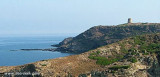
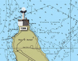
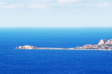
Frasca cape is the N extremity of Piana di Santadi, a plateau, which rises perpendicularly from the sea and is covered with vegetation. It is also the S extremity of the Oristano gulf. A light is shown from a structure, 8m high, standing on the cape.From this cape lies a military ...
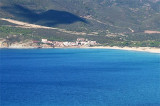
Pecora cape is a small projection, 18 m high, wich is joined to the coast by a low tretch of land. It is dominated 1,3 NM to E by "del Gaurdiano" tip (478 m high).It is shaped by the constant action of water and Mistral.An above-water rock is W of the cape.Between Pecora cape and ...


 Betweene Altano cape and Pecora cape the coast is high and rocky and peaks almost everywhere.
 Entre le cap Altano et le cap Pecora la côte est élevée, rocheuse et presque partout à pic.
 Tra il capo Altano e il capo Pecora la costa è alta e rocciosa di picco quasi ovunque.