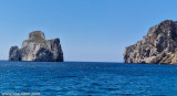
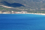
Pecora cape is a small projection, 18 m high, wich is joined to the coast by a low tretch of land. It is dominated 1,3 NM to E by "del Gaurdiano" tip (478 m high).
It is shaped by the constant action of water and Mistral.
An above-water rock is W of the cape.
Between Pecora cape and Frasca cape, 19 NM N, the coast is is steep, rugged, and healthy.
2012/11/7
Update
Le cap Pecora est un saillant de la côte, haut de 18 m, qui est rejoint à la côte par une basse langue de terre. Il est dominé à 1,3 MN à l'E par le pic caractéristique "del Guardiano" (478 m de haut).
Il est modelé par l'incessante action de l'eau et du Mistral.
Un rocher emmergé se trouve sur le côté W du cap.
Entre le cap Pecora et le cap Frasca, à 19M au N, la côte est élevée, escarpée et saine.
2012/11/7
Update
Capo Pecora è un punto culminante della costa, 18 m di altezza, che è collegata alla terraferma da una lingua di terra bassa. È dominato a 1,3 MN all'E dal picco caratteristico "del Guardiano" (478 m di altezza).
E' modellato dall'incessante azione dell'acqua e dal vento di Maestrale.
E' una roccia emersa sul lato W del promontorio.
Tra Capo Pecora e Capo Frasca, a 19MN, N, la costa è alta, ripida e sana.
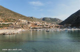
Small marina located in the large Portixeddu bay tra Punta S. Nicolo e Capo Pecora. It is the only possible stop between Carloforte and Oristano. It is in Buggarru town.The Port is limited to yachts with shallow draft. The entrance and funds within the port are especially low because ...
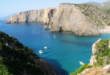
Behind Rama tip is a small deep bay which ends with a sandy beach. It is very picturesque and protected from S winds, but dangerously exposed to the Mistral.
If time permits, you can anchor in the cove splendid.
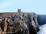
Rama tip, 300 m high, limit, to the W, the small cove Domestica, narrow and rocky.It has a tower that used to guard the cove Domestica entrance where was a small port to embark minerals from various mines in the area.
Porto Flavia is an abandoned mine site since recent decades. Minerals came from Masua, long galleries allowed to carry in the rocky walls and ended directly in the holds of merchant ships moored under the rock wall. Porto Flavia was used for the shipping of minerals.Mining ceased ...


 Pecora cape is a small projection, 18 m high, wich is joined to the coast by a low tretch of land. It is dominated 1,3 NM to E by "del Gaurdiano" tip (478 m high).
 Le cap Pecora est un saillant de la côte, haut de 18 m, qui est rejoint à la côte par une basse langue de terre. Il est dominé à 1,3 MN à l'E par le pic caractéristique "del Guardiano" (478 m de haut).
 Capo Pecora è un punto culminante della costa, 18 m di altezza, che è collegata alla terraferma da una lingua di terra bassa. È dominato a 1,3 MN all'E dal picco caratteristico "del Guardiano" (478 m di altezza).
")
")