Oristano gulf is entered between Capo Frasca and Capo di San Marco, 5,5 NM , NNW.
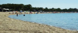
The gulf has low, sandy, and gently sloping shores. In places, there are several whitish sand dunes, with patches of vegetation, backed by extensive lagoons and marshes. Alternating succession sandy beaches and rugged coastline with high cliffs swept by the Mistral makes this coast a favorite spot for surfing.
2012/11/8
Update
Le golfe d'Oristano se trouve entre le cap Frasca et le cap San Marco, 5,5 MN au NNW. Le golfe offre des plages de sable au fond bas et en pente douce. Par endroit, se trouvent des dunes de sable blanchâtre avec des taches de végétation et de vastes lagunes et marais. En alternance se succèdent les plages de sable et la côte déchiquetée avec de hautes falaises balayées par le Mistral qui fait de cette côte un lieu de prédilection pour la pratique du surf.
2012/11/8
Update
Golfo di Oristano si trova tra Capo Frasca e Capo San Marco, 5,5 MN a NNW.
Il Golfo offre spiagge sabbiose alla bassa profondita e con un dolce pendio. In alcuni luoghi, ci sono dune di sabbia bianca con macchie di vegetazione e di ampie lagune e paludi.
A spiagge sabbiose si alternano coste frastagliate e falesie estreme, tutte battute dal
maestrale che fa di questo tratto di mare uno tra i luoghi più ambiti
per il surf nell'isola.
Frasca cape is the N extremity of Piana di Santadi, a plateau, which rises perpendicularly from the sea and is covered with vegetation. It is also the S extremity of the Oristano gulf. A light is shown from a structure, 8m high, standing on the cape.From this cape lies a military ...
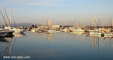
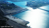
Large commercial harbour in the center of the W coast of Sardinia, S Tirso river. Within the commercial harbor is a marina.To access run through the channel dredged to 13 m, marked by two luminous beacons. Tel: 0783 72262 Fax: 0783 359933 E-mail: oristano@guardiacostiera.it
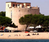
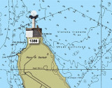
The Aragonese Tower of Torregrande (15 m high) is surrounded by houses. A light is at the top.
It was built on the orders of the Spanish Viceroy Charles V (1537), originally called Tower "puerto de Oristan" (1639), only age Savoy had its current name: "Grande de Oristan" Tower ...
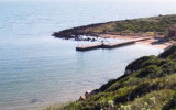
La Caletta is a small cove that lies at the base of the cliffs of Capo San Marco.Located to the interior of Oristano Gulf, it is a natural shelter from the strong winds of the mistral. The small beach marks the transition from the dead sea to the sea alive. La Caletta is part ...


 Oristano gulf is entered between Capo Frasca and Capo di San Marco, 5,5 NM , NNW.
 Le golfe d'Oristano se trouve entre le cap Frasca et le cap San Marco, 5,5 MN au NNW.
 Golfo di Oristano si trova tra Capo Frasca e Capo San Marco, 5,5 MN a NNW.