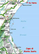
Cala Gonone, located 7.5 miles SW of Punta Nera, can be easily recognized by a group of houses which stand on the shore and interrupt the uninhabited appearance of this part of the coast. Villa Maria Luisa, light blue with yellow shutters, is the most conspicuous building in this ...
Gulf di Tortoli is entered between Isola dell’Ogliastra and Capo Bellavista, marked by a light, 2.5 miles S. Winds from the NW and NE quadrants come up suddenly and blow with extreme violence in this vicinity. They may last for 4 or 5 days and are preceded by whitish clouds ...
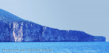
Cape Monte Santu (Monte Santo) is a rocky massif that separates Tortoli of Orosei. It rises perpendicularly from the sea.
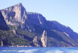
Nearby is the Grotta dei Colombi accessible by sea. In these waters is also the wreck of a cargo 50s. The coast between Capo di Monte Santu and Capo ...
Located between the mouth of Cedrino and wild coast, there is a small cove Foche Pizzina with a small beach with a length of about 350 m, which is located between the mouth of the artificial canal that carries the waters of the river Cedrino at sea and the mouth of the river Foche ...


")
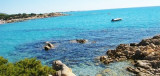
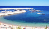
 Beautiful sandy beach Beautiful sandy beach where you can anchor in 5 meters of water.
 Belle plage de sable ou l'on peut mouiller par 5 m d'eau. Au fond 7 grottes caractéristiques.
 L'ottava meraviglia del mondo!
")
")
")