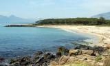
Located between the mouth of Cedrino and wild coast, there is a small cove Foche Pizzina with a small beach with a length of about 350 m, which is located between the mouth of the artificial canal that carries the waters of the river Cedrino at sea and the mouth of the river Foche ...
Tavolara island is a limestone massif 6 kilometres long and 500 m wide, and 565 m high.The overhanging cliffs make it inaccessible, with the exception of a bay and a beach that is located at each end of the island, Spalmatore di Fuori northeast (military zone) and Spalmatore di Terra ...
Cala Gonone, located 7.5 miles SW of Punta Nera, can be easily recognized by a group of houses which stand on the shore and interrupt the uninhabited appearance of this part of the coast. Villa Maria Luisa, light blue with yellow shutters, is the most conspicuous building in this ...
S Ginepro point is the beautiful Ginepro cove sheltered from westerly winds.Beware, for those coming from N don't pull over immediately to the beach: the S side of the point is fringed with rocks (scoglio Marchesa).We anchor in 5/6 m.
Gulf di Tortoli is entered between Isola dell’Ogliastra and Capo Bellavista, marked by a light, 2.5 miles S. Winds from the NW and NE quadrants come up suddenly and blow with extreme violence in this vicinity. They may last for 4 or 5 days and are preceded by whitish clouds ...


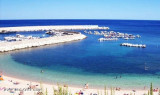
 SW Punta Nera, on the River Cedrino, a small port was built, but it can only accommodate small structures.
 Au SW de Punta Nera, sur la rivière Cedrino, un petit port a été aménagé, mais il ne peut accueillir que les petites structures.
 SW Punta Nera, sul fiume Cedrino, un porticciolo è stato costruito, ma può ospitare solo piccole strutture.
")
")
")
")