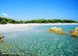
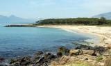
Located between the mouth of Cedrino and wild coast, there is a small cove Foche Pizzina with a small beach with a length of about 350 m, which is located between the mouth of the artificial canal that carries the waters of the river Cedrino at sea and the mouth of the river Foche Pizzina.
Day anchorage, when weather permitting.
2012/10/9
Update
Joëlle
Nichée entre l'embouchure du Cedrino et de la côte sauvage, il y a la petite anse Foche Pizzina avec une petite plage d'une longueur d'environ 350 m, qui est située entre la bouche du canal artificiel qui porte les eaux de la rivière Cedrino à la mer et la bouche de la rivière Foche Pizzina.
Mouillage de jour, par beau temps.
2012/10/9
Update
Joëlle
Incastonata tra la foce del Cedrino e la costa frastagliata, c'è la piccola cala Foche Pizzinna con una piccola spiaggia lunga circa 350 metri, che si trova tra lo sbocco in mare canale artificiale che convoglia le acque del fiume Cedrino, e la foce del Rio Foche Pizzinna.
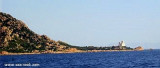
Tavolara island is a limestone massif 6 kilometres long and 500 m wide, and 565 m high.The overhanging cliffs make it inaccessible, with the exception of a bay and a beach that is located at each end of the island, Spalmatore di Fuori northeast (military zone) and Spalmatore di Terra ...
S Ginepro point is the beautiful Ginepro cove sheltered from westerly winds.Beware, for those coming from N don't pull over immediately to the beach: the S side of the point is fringed with rocks (scoglio Marchesa).We anchor in 5/6 m.
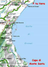
Cala Gonone, located 7.5 miles SW of Punta Nera, can be easily recognized by a group of houses which stand on the shore and interrupt the uninhabited appearance of this part of the coast. Villa Maria Luisa, light blue with yellow shutters, is the most conspicuous building in this ...
Capo Comino the E extremity of Sardegna, is low, rocky, fringed by reefs. A light is shown from structure, 20m high, standing on the cape. A disused signal station is situated 0.2 mile WSW of the light.N cape Comino is Ruja (or Ruia) islet.


 Located between the mouth of Cedrino and wild coast, there is a small cove Foche Pizzina with a small beach with a length of about 350 m, which is located between the mouth of the artificial canal that carries the waters of the river Cedrino at sea and the mouth of the river Foche Pizzina.
 Nichée entre l'embouchure du Cedrino et de la côte sauvage, il y a la petite anse Foche Pizzina avec une petite plage d'une longueur d'environ 350 m, qui est située entre la bouche du canal artificiel qui porte les eaux de la rivière Cedrino à la mer et la bouche de la rivière Foche Pizzina.
 Incastonata tra la foce del Cedrino e la costa frastagliata, c'è la piccola cala Foche Pizzinna con una piccola spiaggia lunga circa 350 metri, che si trova tra lo sbocco in mare canale artificiale che convoglia le acque del fiume Cedrino, e la foce del Rio Foche Pizzinna.
")
")