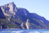
Le cap de Monte Santu (Monte Santo) est un promontoire massif qui sépare Tortoli d'Orosei. Il tombe à pic sur la mer.
A proximité se trouve la Grotta dei Colombi accessible par voie maritime. Dans ces eaux se trouve également l'épave d'un cargo des années 50.
La côte entre le cap de Monte Santu et le cap Bellavista est haute, rocheuse et inaccessible pendant les 6 premiers miles, puis elle devient basse et sablonneuse.
2012/10/11
Update
Joëlle
Capo Monte Santu (Monte Santo) è un massiccio promontorio che divide Tortolì da Orosei.
Spetta ripidamente verso il mare.
Nelle vicinanze si trova la Grotta dei Colombi raggiungibile via mare. In queste acque si trova anche il relitto di un mercantile degli anni
50.
La costa tra capo di Monte Santu e capo Bellavista è alta, rocciosa e inaccessibile durante i primi 6 km, poi diventa bassa e sabbiosa.
Gulf di Tortoli is entered between Isola dell’Ogliastra and Capo Bellavista, marked by a light, 2.5 miles S. Winds from the NW and NE quadrants come up suddenly and blow with extreme violence in this vicinity. They may last for 4 or 5 days and are preceded by whitish clouds ...
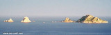
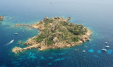
Isola dell’Ogliastra, 47m high, lies 3 miles S of Punta Pedra Longa and is in front of Lotzorai beach. It is reddish, rocky, and covered with scanty vegetation. Several rocks extend up to 0.2 mile seaward off its NE side.There are many coves that offer tamporal anchorage . The ...
Anchorage can be taken, in a depth of 15m, sand and weed, about 0.2 mile SSW of Isola dell’Ogliastra or in a depth of 8m, about 200m W of the islet, but these berths are dangerous in SE winds.
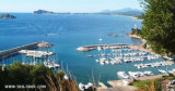
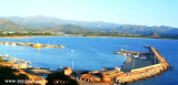
The port of Arbatax lies in the S part of Golfo di Tortoli and on the N side of the promontory of Capo Bellavista. It is the only refuge on the E coast of Sardegna to the S of Olbia.
Tel. 0782.667405 Fax 0782.664359 Berths: 400 Berths Transit: 150 (<80 m)


 Cape Monte Santu (Monte Santo) is a rocky massif that separates Tortoli of Orosei. It rises perpendicularly from the sea.
")
 Le cap de Monte Santu (Monte Santo) est un promontoire massif qui sépare Tortoli d'Orosei. Il tombe à pic sur la mer.
 Capo Monte Santu (Monte Santo) è un massiccio promontorio che divide Tortolì da Orosei.
Spetta ripidamente verso il mare.
Capo Monte Santu (Monte Santo) è un massiccio promontorio che divide Tortolì da Orosei.
Spetta ripidamente verso il mare.")