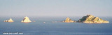
Pedra Longa tip, with its red rock shaped column is characteristic except of E where it merges with the rocky Mount Ginnircu where it projects.
2012/10/10
Update
Joëlle
La pointe Pedra Longa, avec son rocher rouge en forme de colonne, est caractéristique sauf de l'E où elle se confond avec la partie rocheuse du Mont Ginnircu d'où elle se projette.
2012/10/10
Update
Joëlle
Punta Pedra Longa, con la sua roccia rossa a forma di colonna, è caratteristica eccetto dal'E dove si si fonde con il monte roccioso Ginnircu di cui si projetta.
Gulf di Tortoli is entered between Isola dell’Ogliastra and Capo Bellavista, marked by a light, 2.5 miles S. Winds from the NW and NE quadrants come up suddenly and blow with extreme violence in this vicinity. They may last for 4 or 5 days and are preceded by whitish clouds ...
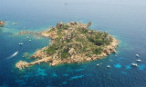
Isola dell’Ogliastra, 47m high, lies 3 miles S of Punta Pedra Longa and is in front of Lotzorai beach. It is reddish, rocky, and covered with scanty vegetation. Several rocks extend up to 0.2 mile seaward off its NE side.There are many coves that offer tamporal anchorage . The ...
Anchorage can be taken, in a depth of 15m, sand and weed, about 0.2 mile SSW of Isola dell’Ogliastra or in a depth of 8m, about 200m W of the islet, but these berths are dangerous in SE winds.
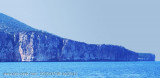
Cape Monte Santu (Monte Santo) is a rocky massif that separates Tortoli of Orosei. It rises perpendicularly from the sea.
Nearby is the Grotta dei Colombi accessible by sea. In these waters is also the wreck of a cargo 50s. The coast between Capo di Monte Santu and Capo ...
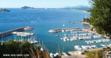
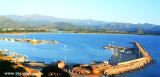
The port of Arbatax lies in the S part of Golfo di Tortoli and on the N side of the promontory of Capo Bellavista. It is the only refuge on the E coast of Sardegna to the S of Olbia.
Tel. 0782.667405 Fax 0782.664359 Berths: 400 Berths Transit: 150 (<80 m)


 Pedra Longa tip, with its red rock shaped column is characteristic except of E where it merges with the rocky Mount Ginnircu where it projects.
 La pointe Pedra Longa, avec son rocher rouge en forme de colonne, est caractéristique sauf de l'E où elle se confond avec la partie rocheuse du Mont Ginnircu d'où elle se projette.
 Punta Pedra Longa, con la sua roccia rossa a forma di colonna, è caratteristica eccetto dal'E dove si si fonde con il monte roccioso Ginnircu di cui si projetta.
")
")
")
")