Canale di S. Pietro (Sardinia)

Canale di S. Pietro (Sardinia)

To precisely geolocate this site. Update if necessary.

Localisation

Characteristics

Canal

Description

Channel S. Pietro is the arm of the sea which lies between S. Pietro island in W, and S. Antioco island and the Sardinia coast to E.

The maximum draugh permitted in the channel is 5m, many shoals obstruct the channel and restrict the passage.

At the level of Caloforte, a continuous zone of shoals cross the canal and joined the dangers that go far beyond the E and W shores. The channel oriented approximately NS, run along the coast of the island of S. Pietro to 1NM distant.

Each of N and S ends is marked by a buoy with black and white mas.

At the N entrance of the channel, NE Piana island, secca Grande, covered with 3m of water, is marked to SE by a bright buoy red and black.

2012/10/28
Update
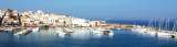
Le canal de S. Pietro est le bras de mer qui s'étend entre l'île S. Pietro à l'W, et l'île S. Antioco et la côte de Sardaigne à l'E.

Le TE maximal admis dans le chenal est 5m, de nombreux hauts-fonds obstruent le chenal et le rétrécissent.

A hauteur de Carloforte, une zone continue de hauts-fonds traverse le canal et rejoint les dangers qui débordent largement les rives E et W. Le chenal orienté à peu près NS, longe la côte de l'île de S. Pietro à 1MN environ de distance.

Chacune des extrémités N et S est marquée par une bouée à mât noir et blanc.

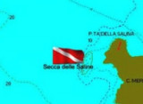
A l'entrée N du canal, au NE de l'île Piana, la sèche Grande, couverte de 3m d'eau, est marquée au SE par une bouée lumineuse rouge et noire.
2012/10/28
Update
Il canale di S. Pietro è il braccio di mare che si trova tra l'isola di S. Pietro in W, e l'isola S. Antioco e la costa della Sardegna in E.

Il pescaggio di massima consentita nel canale è 5 m, molti banchiostacolano il canale e lo rende stretto.

A Caloforte, una zona continua di secche attraversano il canale e si unìssono ai pericoli che vanno ben oltre i confini di E e W. Il canale orientato circa NS, è distante di 1 MN dalla costa dell'isola di S. Pietro.

Ciascuno degli N e S estremite è delimitata da una boa con uno mast bianco e nero.
All'ingresso Ndel canale, NE dell'isola Piana, secche Grande, coperta di 3 m di acqua, è caratterizzata a SE da una boa luminosa rossa e nera.

2012/10/28
Update
Ebook

Sardegna West

  • 122 sites
  • 310 photos
  • publication date: 11 Jul 2023
  • .pdf file size: 59 Mb
Share your comments or photos on "Canale di S. Pietro (Sardinia)"

Sites around Canale di S. Pietro (Sardinia)

Flying distances - Direct line

Marina Sifredi Porto di Carloforte (S. Pietro Sardegna)

1.7nm
326°
Marina Sifredi, SW Sardinia, is on the E side of Isola di San Pietro, close to the only town on the island, Caloforte.
Marina Sifredi has two marinas located respectively in the North and South of Caloforte harbour.
Sifredi marina is in the N and S area of Caloforte harbour.
Mamma ...
28 Oct 12
Joëlle

Porto Turistico di Calasetta (S Antioco Sardegna)

1.7nm
104°
Calasetta commercial port, with low depth, is E of the marina.
Visitors can accost at the "B" quay, in 4 m.Beware secca del Francese (2,9 m) N harbour, marked by a N cardinal mark. T. 88930 2 b. visit. (<16 m)Calasetta marina:Outside the commercial port, to W is the Calasetta ...
31 Oct 12

Cala delle Saline (S Antioco Sardegna)

1.7nm
141°
After the tip delle Saline is a pond behind the beach, and Delle Saline beach continues to expand with sand dunes covered with abundant vegetation that separates the pond.

This cove is popular with windsurfers who take advantage of the wind blowing offshore.

Well sheltered ...
31 Oct 12

Punta Nera (S Pietro Sardegna)

1.8nm
226°
Punta Nera, S Caloforte, so named because of its dark color of its rocks. It is characterized by shallow water and flat land cultivated, dotted with white houses.
28 Oct 12
Joëlle