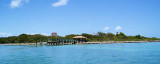
Long Key (ou Rattlesnake key) (Florida Keys)
9.2nm
265°
In the early 20th century, Long
Key was the site of a luxurious fishing resort that ...
5 Apr 10
Joëlle
| Latitude | Longitude | |
| DMS | --- | --- |
| DM | --- | --- |
| DD | --- | --- |


")
")
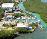
 Alligator Reef is located 200 yards offshore of Alligator
USS Alligator was launched, November 2, 1820, and commissioned in
March 1821. Alligator's short, but intensive, period of naval service was
involved with combating the problem of the slave trade.
In 1821,
Alligator was dispatched to the coast of Africa, where her officers
helped negotiate the purchase of Liberia as an American protectorate. The
new territory was intended to serve as a haven for former American slaves,
where they could start a new life.
Alligator was one of the first
Navy ships dispatched to Florida following the acquisition of
Florida by
the U.S. from Spain in 1821. Alligator was assigned patrol duty to
help suppress the rampant piracy which existed in the Florida
Keys, and
off the coasts of Cuba.
While returning from a naval action against
pirates off the coast of Cuba, Alligator ran aground on
Carysford
(later renamed Alligator) Reef, in the Florida Keys, near present-day
Islamorada, on November 19, 1822. When Alligator's officers and
crew determined that she couldn't be saved, they set fire to her to
prevent her re-capture by pirates. The vessel exploded when fire reached
her munitions' areas. Her officers and crew were rescued and taken off the
Reef.
Alligator may be considered to be the first Navy ship wrecked
in Florida.
The site of USS Alligator is located in the Florida Keys
National Marine Sanctuary (FKNMS) and its location has been generally
known by divers for many years. The site of USS Alligator is
presently being nominated to the National Register of Historic
Places by
the Naval Historical Center. A brief reconnaissance survey project was
completed in October 1995 by several state and federal agencies.
One
longer-term objective is to determine a management strategy for the site.
Mooring Buoys: E 24 50.98 80 36.84 S 24
50.51 80 37.35
W 24 50.81 80 37.63 N 24 51.23
80 37.17
Depth: 8' to 40'
 Alligator Reef est situé à 180 m du feu d'Alligator, entre les têtes de corail, à 3,5 MN au SE de Lower Matecumbe Key.
USS Alligator a été lancé
2 Novembre 1820, et mis en service en Mars 1821. Alligator est une courte, mais intense, période de service de la marine qui a été impliquée dans la lutte contre le problème de la traite négrière.
En 1821, Alligator a été envoyée sur la côte d'Afrique, où ses agents ont aidé à négocier l'achat du
Libéria comme un protectorat américain. Le nouveau territoire devait servir de refuge aux anciens esclaves américains, où ils pourraient commencer une nouvelle vie.
Alligator est l'un des navires de la Marine dépêché en Floride, suite à l'acquisition de la
Floride par les États-Unis en 1821. Alligator a été affecté au service de patrouille pour aider à réprimer la piraterie endémique qui existait dans les Florida Keys, et au large des côtes de Cuba.
En revenant d'une action navale contre les pirates au large des côtes de Cuba, Alligator s'échoua sur Carysford (plus tard rebaptisé Alligator) Reef, dans les Florida
Keys, près de l'actuel Islamorada, le 19 Novembre 1822. Lorsque les officiers d'Alligator et son équipage ont déterminé qu'ils ne pouvaient pas sauver le navire, ils y ont mis le feu pour l'empêcher d'être capturé par les pirates. Le navire a explosé lorsque le feu a atteint les zones de munitions. Ses officiers et l'équipage ont été secourus et transportés hors du récif.
Alligator peut être considéré comme le premier navire de la Marine ayant fait naufrage en Floride.
Le site de l'USS
Alligator est situé dans le Florida Keys National Marine Sanctuary (FKNMS) et son emplacement est généralement connu par les plongeurs depuis de nombreuses années.
Le site de l'USS
Alligator est actuellement en nomination pour le Registre national des lieux historiques par le Centre historique de la marine. Une brève enquête pour un projet de reconnaissance a été achevée en Octobre 1995 par plusieurs
Etats et organismes fédéraux. Un objectif à plus long terme est de déterminer une stratégie de gestion du site.
Bouées de mouillage: E 24 50.98 80 36.84 S 24
50.51 80 37.35
W 24 50.81 80 37.63 N 24 51.23
80 37.17
Profondeurs: 2,4 à 12 m.
Ebook | Gulf of Mexico
|