The island lies to the southwest of Upper Matecumbe Key, and to the northeast of Craig Key. All of the key is within the Village of Islamorada as of November 4, 1997, when it was incorporated. This key is the site of a number of Indian mounds and middens, most of which were destroyed during the building of the Overseas Railroad.
A number of natural wells were also located here, at the northeast end of the key. These wells were well known to early seafaring men as the most reliable source of fresh water in the Keys. They, too were destroyed during the railroad era, and the location of their site has been lost. The southwestern end of the key is the site of a former sand mining operation.
2010/03/22
Update
Joëlle
L'île est située au sud-ouest de la Haute-Matecumbe Key, et au nord-est de Craig Key. Cette clé est le site d'un certain nombre de monticules indiens et tertres, dont la plupart ont été détruits pendant la construction du chemin de fer d'outre-mer.
Un certain nombre de puits naturels ont également été installées ici, à l'extrémité nord de la clé. Ces puits étaient bien connues de l'homme au début de l'aventure maritime comme source la plus fiable d'eau douce dans les Keys. Eux aussi ont été détruits pendant l'ère du chemin de fer, et l'emplacement de leur site a été perdu. L'extrémité sud-ouest de la clé est le site d'une ancienne exploitation du sable.
Long Key was called Cayo Vivora (Rattlesnake Key) by early Spanish explorers, a reference to the shape of the island, which resembles a snake with its jaws open, rather than to its denizens. In the early 20th century, Long Key was the site of a luxurious fishing resort that ...
Key Vaca is an island in the middle Florida Keys, located entirely within the borders of the city of Marathon, Florida. It is often incorrectly identified as "Marathon Key."Key Vaca is located between Fat Deer Key and Knight's Key. Key Vaca is also connected via bridge to ...
Anchorage located at South/southeast of the ICW's unlighted daybeacon #97.To avoid the 1 foot shallows of Peterson Bank, westbound cruisers must follow the waterway's track for another 6 M or so southwest of #97 before turning to southeast and heading for the bight. Minimum depth: ...
Lignumvitae Key is an island in the upper Florida Keys. It is located due north of, and less than one mile from the easternmost tip of Lower Matecumbe Key. The island has the Keys' highest point above sea level of 19 feet (5.8 m), which beats the island of Key West's Solares ...
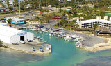
Caloosa Cove Marina is located in Florida Keys, USA S. The facility combines slips and boat yard. L'installation combine glisse et chantier naval. It is popular with anglers, limited depths preclude large deep draught vessels.Caloosa Cove Marina lies on the SW tip of Lower Matecumbe ...
The entrance to the 6 foot minimum depth Lignumvitae Channel lies just west of the like-named Key. Cruiserheaded for this cut from the ICW can leave the Waterway's track, 6 M SW of unlighted daybeacon #91A. The Northernmost aids to navigation on the Lignumvitae Channel are unlighted ...


 The island lies to the southwest of Upper Matecumbe Key, and to the northeast of Craig
 L'île est située au sud-ouest de la Haute-Matecumbe Key, et au nord-est de Craig Key.