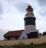

Kanyakumari Port (S India)
0.2nm
332°
Depths in the boat basin and alongside the pier are 2.3m or less.
19 Mar 12
Jojo
| Latitude | Longitude | |
| DMS | --- | --- |
| DM | --- | --- |
| DD | --- | --- |

Ebook | Bay of Bengal
|
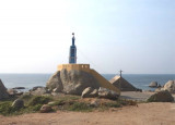
 Vivekananda Rock Memorial is a sacred monument and popular tourist
attraction in Kanyakumari, India.
Vivekananda Rock Memorial is a sacred monument and popular tourist
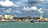
attraction in Kanyakumari, India.The Thiruvalluvar Statue is a 133 feet (40.5 m) tall stone sculpture of the Tamil poet and saint Tiruvalluvar, author of the Thirukkural. It was opened in January 1, 2000 (Millenium) and is located atop a small island near the town of Kanyakumari, where two seas and an ocean meet; the Bay of Bengal, the Arabian Sea, and the Indian Ocean . The statue has a height of 95 feet (29 m) and stands upon a 38 foot (11.5 m) pedestal that represents the 38 chapters of "virtue" in the Thirukkural. The statue standing on the pedestal represents "wealth" and "pleasure", signifying that wealth and love be earned and enjoyed on the foundation of solid virtue.