
Muttam Point (W India)
4.8nm
126°
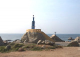
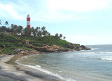
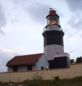
A light, with a racon, is shown on the point. A group of palmyra trees on high red ground, about 1 mile N of the light structure, forms ...
19 Mar 12
Jojo
| Latitude | Longitude | |
| DMS | --- | --- |
| DM | --- | --- |
| DD | --- | --- |

")
Ebook | Arabian Sea
|
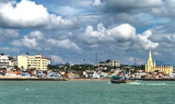
 Kolachel (Colachel) is an open roadstead with anchorage in about 13m in the lee of four small islets. The port is important for the export of ilmenite sand.
The depths shoal gradually from 21m in the outer anchorage to 10m about 0.2 mile offshore in the area E of the town.
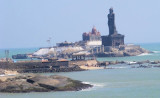
Several rocks, above and below-water, extend up to about 0.3 mile S and SW of Kolachel. Kurusukal, 6m high and surmounted by a white shrine carrying a black cross, lies about 183m S of Kolachel Light.
Ahnakal, 3m high, lies close SSE of Kurusukal, with a rock awash close SE of it.
Pulleri, 1m high, the SE danger in the approach to Kolachel, lies about 0.3 mile SSE of Kurusakal.
Patna Rock and Constance Rock, with depths of 2m, lie about 183m W and 0.5 mile WNW, respectively, of Pulleri.
Storm signals, using the Brief System, are displayed from a flagstaff 0.4 mile E of Kolachel Light.
Tel: +91 442 5670959
Fax: +91 442 5673035
Mail: hwaysec@tn.gov.in