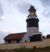
Comorin Lighthouse (S India)
0.8nm
79°
Good radar returns have been reported from Cape Comorin at 23 miles.
19 Mar 12
Jojo
| Latitude | Longitude | |
| DMS | --- | --- |
| DM | --- | --- |
| DD | --- | --- |

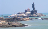
 Cape Comorin, the S extremity of India, is low and sandy, with a small white pagoda on its extremity.
This pagoda is surrounded by a high wall, above which the top of the pagoda may be seen. A bungalow lies NW of the pagoda. A conspicuous memorial, 37m high, lies close W of the cape. The coast close W of the pagoda is barren and sandy, but is wooded NE of it.
Foul ground extends about 0.5 mile S and SE from the cape.
An area of foul ground lies 1.5 miles offshore, about 6 miles W of Cape Comorin.
The land rises gradually N of Cape Comorin so that from a distance the cape appears as a sandy promontory. A mountain, 370m high, about 4 miles NW of the cape, appears as a pointed cone except from E or S. A range, about 9 miles farther N, with heights up to 1,041m, resembles a camel’s hump.
Cape Comorin is the most southern point in India, where 3 bodies of water meet: the bay of Bengal (E), the Indian ocean (S) and the Arabian sea (W).
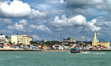
At the cape is the town of Kanyakumari that is a fishing village.
The tidal currents off Cape Comorin set E during the flood and W during the ebb, but their direction and strength are much affected by the ocean currents.
The coast between Cape Comorin and Manappad Point, about 35.5 miles ENE, is somewhat higher than the remainder of the NW coast of the Gulf of Mannar, with undulating sand hills up to 60m high. The background consists of reddish soil and rises gradually to the foot of the Southern Ghats a few miles inland. Many villages and whitewashed churches lie along this coast, but landing in a ship’s boat is always difficult and dangerous.
An obelisk, 8m high, lies on the coast about 2 miles N of Cape Comorin, and serves to mark the position of a stranded wreck about 0.5 mile ESE.
Caution.—When approaching Cape Comorin from the NW during the Northeast Monsoon, a vessel sheltered by the coast as far as Muttam Point, about 14 miles W of the cape, may suddenly pass from a calm into the strength of the monsoon, even if already well offshore.
A dangerous obstruction was reported (2002) to lie about 8 miles WSW of Comorin Point.
")
Ebook | Bay of Bengal
|