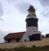
Cape Comorin Light is shown from a square white tower, 34m high, and painted in red bands, about 0.3 mile NW of the cape. A church, 54m high, lies in a village about 0.5 mile N of the cape. Good radar returns have been reported from Cape Comorin at 23 miles.
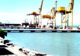
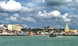
Kanyakumari is a town that is at the tip of the Indian Peninsula and faces the Indian Ocean.The port is a minor port primarily for ferry traffic. Depths in the boat basin and alongside the pier are 2.3m or less.
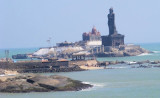
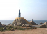
Vivekananda Rock Memorial is a sacred monument and popular tourist
attraction in Kanyakumari, India. The memorial stands on one of two
rocks located about 500 meters off mainland India's southernmost tip.
It was built in 1970 by the Vivekananda Rock Memorial Committee in
honour ...
Cape Comorin, the S extremity of India, is low and sandy, with a small white pagoda on its extremity. This pagoda is surrounded by a high wall, above which the top of the pagoda may be seen. A bungalow lies NW of the pagoda. A conspicuous memorial, 37m high, lies close W of the ...
Muttam Point (Muttum Point), 35m high and with steep red cliffs, lies about 5.5 miles SE of Kolachel. The village of Muttamtura lies on the point. A light, with a racon, is shown on the point. A group of palmyra trees on high red ground, about 1 mile N of the light structure, forms ...
East Cape is prominent, and the coastal reef, with depths of 5.5m, extends about 1 mile offshore near the cape.AnchorageShelter from W winds can be found in the bight between Cape Comorin and East Cape, but during the Southwest Monsoon landing by ship’s boats should not be attempted ...
Kolachel (Colachel) is an open roadstead with anchorage in about 13m in the lee of four small islets. The port is important for the export of ilmenite sand. Vessels of 10,000 15,000 grt have called here. Landing during good weather is fairly easy as the rocks off the village form ...


 Cape Comorin Light is shown from a square white tower, 34m high, and painted in red bands, about 0.3 mile NW of the cape. A church, 54m high, lies in a village about 0.5 mile N of the cape.