
Kolachel Port (W India)
4.8nm
305°
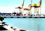
Vessels of 10,000 15,000 grt have called here. Landing during good weather is fairly easy as the rocks off the village form ...
20 Mar 12
Jojo
| Latitude | Longitude | |
| DMS | --- | --- |
| DM | --- | --- |
| DD | --- | --- |

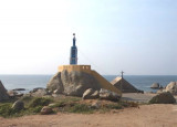
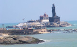
 Muttam Point (Muttum Point), 35m high and with steep red cliffs, lies about 5.5 miles SE of Kolachel. The village of Muttamtura lies on the point.
A light, with a racon, is shown on the point. A group of palmyra trees on high red ground, about 1 mile N of the light structure, forms a good landmark which can usually be seen above mist which may obscure the lighthouse.
Muttam Point has been reported to give a good radar response at 18 miles.
Crocodile Rock, a dangerous sunken rock about 3 miles SW of Muttam Point Light, is the outermost danger; the sea does not break over it in calm weather. Adunda Rock, 5m high, lies about 1.3 miles SW of the point. It is difficult to identify from seaward, and foul ground extends about 0.2 mile NNW from it.
Kota Rock, 6m high and steep-to on its W side, lies about 1.3 miles WNW of Adunda Rock. Vessels should not pass inside of Adunda and Kota Rocks.
")
")
Ebook | Arabian Sea
|