Zupski Zaliv is entered between Rt Sustjepan and Rt Pelegrin, 2.5 miles NW. The E and SE shores of this bay are backed by mountains, but a valley through which a river flows lies within the N shore. Malastica, 628m high, stands 1 mile N of the bay. This hill has a somewhat sharp peak and is prominent from seaward. A conspicuous church stands on the NW side of the bay.
2011/04/13
Update
Jojo
Zupski Zaliv estla zone comprise entre Rt Sustjepan et Rt Pelegrin,à 2,5 miles au NW. Les rives E et SE de cette baie sontprotégées par des montagnes, mais une vallée à travers laquelle coule une rivière se situe dans la rive nord. Malastica, 628m de haut, s'élève à 1 mile au N de la baie. Cette colline abrupte est très visible de la mer. Une église remarquable est située sur la rive nord-ouest de la baie.
It is the largest and most populated island of the group Elafiten. It rises to 234 m at its N and a prominent hill rises 224 m NW of the SE end. Ruda is a small island that is 0.5 M SE of the NE extremity of the island and Misnjaka, 13 m high, lies close off the NW extremity. ...
The middle bay of Boka Kotorska, is connected to Topaljski Zaliv by Kumborski Strait, a deep passage. This bay is steep and rocky on its S side, but the NE and NW shores, which are backed by mountains, are low and cultivated. Uvala Kukuljina and UvalaKrtole, separated from each ...
Otocic Cavtatski Grebeni, a group of islets and above-water rocks, lies up to 2 miles W of Rt Sustjepan, on a line NW-SE parallel to the coast. Otocic Mrkan, the largest islet, is 65m high and appears dark from seaward. NW is the island Bobara. Between the two islands are ...
The island of Supetar and the shoal with a rock discovered, halfway between Supetar and extend the course to 0.7 NM NW of Rt Sv Rok. Do not get too close to the island because of the rocks that surround it. Island Supetar is 8 m high and a prominent building rises to its summit. Hr ...
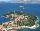
Rt Sustjepan (42°35'N., 18°13'E.), 49m high, is the NW extremity of a narrow projection which extends 1 mile NW from the coast.Rt Rat is the NW extremity of a similar projection, 42m high, located 0.3 mile NE. Cavtatska Luka, an inlet, is entered between these points; the town of ...


 Zupski Zaliv is entered between Rt Sustjepan and Rt Pelegrin, 2.5 miles NW. The E and SE shores of this bay are backed by mountains, but a valley through which a river flows lies within the N shore.
 Zupski Zaliv estla zone comprise entre Rt Sustjepan et Rt Pelegrin,à 2,5 miles au NW. Les rives E et SE de cette baie sontprotégées par des montagnes, mais une vallée à travers laquelle coule une rivière se situe dans la rive nord.