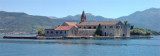
The middle bay of Boka Kotorska, is connected to Topaljski Zaliv by Kumborski Strait, a deep passage. This bay is steep and rocky on its S side, but the NE and NW shores, which are backed by mountains, are low and cultivated. Uvala Kukuljina and UvalaKrtole, separated from each other by a group of islands and a reef, lie in the SE part of this bay and are backed by the lowlands of the valley of Zupa. The NW shore of the bay is fairlywell populated with several small towns, some of which are fronted by piers suitable for coasters. The Naval Base of Tivat is situated along the E shore of the bay.
2011/04/12
Update
Jojo
La baie du milieu des Bouches du Kotor est reliée à Topaljski Zaliv par le détroit de Kumbborski qui est un passage profond. Cette baie est escarpée et rocheuse au S, mais les rives N et NW sont basses et cultivées et se terminent par les montagnes. Uvala Kukuljina et Uvala Krtole, séparées les unes des autres par un groupe d'îles et un récif, se trouvent dans la partie sud de cette baie et sont soutenues par les basses terres de la vallée de Zupa. La rive nord-ouest de la baie est accueillante,l peuplée par plusieurs petites villes, dont certaines sont bordées de pontons appropriés pour les caboteurs. L'ex base navale de Tivat, aujourd'hui Porto Montenegro, est située le long de la rive E de la baie.
2011/04/12
Update
Jojo
La baia centrale delle Bocche di Cattaro è collegata a Topaljski Zaliv dallo stretto di Kumbborski, che è un passaggio profondo. Questa baia è ripida e rocciosa a S, ma le sponde N e NW sono basse e coltivate e terminano in montagna.Uvala Kukuljina e Uvala Krtole, separate l'una dall'altra da un gruppo di isole e da una scogliera, si trovano nella parte meridionale di questa baia e sono sostenute dalle pianure della valle di Zupa.La sponda nord-occidentale della baia è accogliente, popolata da diversi piccoli centri abitati, alcuni dei quali fiancheggiati da pontili adatti alle montagne russe.L'ex base navale di Tivat, oggi Porto Montenegro, si trova lungo la costa E della baia.
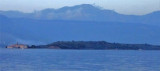
Plicina Jezicac, nearly awash, lies at the outer end of a spit which extends about 0.5 mile WNW from the N extremity of Ostrvo Stradioti. Vessels should not attempt to pass between this reef and the islands to the E.
Ostrvo Stradioti, the largest of the islands lying in the SE part of the bay, is 37m high and is marked by several beacons at its W extremity. It is easily recognized against the lowlands in the background.
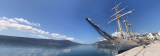
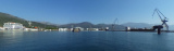
Tivat is located on the coast of E Tivatski Zaljev is an administrative center and a tourist town. Nearby there is an airport and an arsenal. The public dock is located SE of the arsenal. Can moor along the wharf next available space. The dock is dangerous winds W.
Tivat is a luxury yacht marina and adjacent waterfront
development currently under construction. The construction site was a
naval shipyard named Arsenal, which fell into disuse after the wars and
the decline of the Yugoslav Navy. The attractive lot on which the
shipyard is situated ...


 The middle bay of Boka Kotorska, is connected to Topaljski Zaliv by Kumborski Strait, a deep passage.
 La baie du milieu des Bouches du Kotor est reliée à Topaljski Zaliv par le détroit de Kumbborski qui est un passage profond.
 La baia centrale delle Bocche di Cattaro è collegata a Topaljski Zaliv dallo stretto di Kumbborski, che è un passaggio profondo.