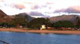
Waimea bay is located in Haleiwa, on the N shore of Oahu, at the mouth of the Waimea river. Waimea valley extends behind Waiema bay.
Waiema means "red water" in Hawaiian.
Captain Charles Clerke aboard HMS Resolution stopped at Waimea Bay on February 28, 1779. Clerke had shortly before taken command of the ship after Capt. James Cook was killed at Kealakekua Bay
on February 14. Waimea Bay was the only O'ahu anchorage visited by the
expedition. Waimea Valley was densely populated at the time, and the
remains of Pu'u o Mahuka, an important heiau (Hawaiian temple) can still be seen above the bay.
Protected during Summer and early Fall with consistent trade winds.
This is a huge anchorage directly in front of a wide valley. The valley was use for bombing
practice during WWII. You can still see the observation towers used by the military. Now,
however, a fight has erupted between the government and the Hawaiians over the protection of
the ...
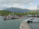
North part of Pokai Bay beach Central part of Pokai Bay beach The Waianae Harbor entrance as seen from inside the Pokai Bay breakwater. Pokai Bay is a small anchorage in an old harbor on the west side of Oahu. Room for about 4 or 5 boats to anchor. Very protected except ...
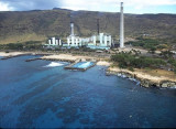
The prominent smoke stcks of the Hawiian Electric power plant are
an obvious landmark.
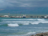
The Mehaffy guide claims that the trade winds are "reduced to a whisper".We anchored in about 9 meters of water so clear that ripples on the sand
were easily discernable. While there's not ...
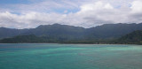
This bay is on the north east coast of Oahu and is protected by the Mokapu Peninsula. This bay is very calm and sheltered. Together with the crystal clear water, it makes a very attractive anchorage.
There are four marinas here as well as four anchorage areas.
Anchor in the North ...
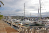
This is the only "real" marina in Hawaii. It has:
floating docks
a fuel dock
laundry
showers
gas barbecues
easy access to swimming lagoons
The marina listens on VHF 71 and likes to clear traffic in and out as
there is very little manoeuvering room in the chanel. Commercial
traffic ...
Located on the southwestern shore of Kane'ohe Bay. Adress 46-499 Kamehameha Hwy.,
Kaneohe, Hawaii 96744Water, toilets,
showers, fuel and pump-out facility. Call the harbour master for berth
allocation.Tel: (808) 233-3603 Fax: (808) 233-3602 Mail: heeia.kea.harbor@hawaii.gov 21 ...


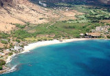


 Waimea bay is located in Haleiwa, on the N shore of Oahu, at the mouth of the Waimea river. Waimea valley extends behind Waiema bay.
")