Vela Luka Korcula

Vela Luka Korcula

To precisely geolocate this site. Update if necessary.

Localisation

Characteristics

Port
Grass
Mooring
Sand
Water au poste de carburant
Electricity NE du poste de carburant
Fuel
First aid
Mechanical repair
Market
Restaurant
Post
Bank

Description

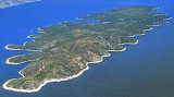
Vela Luka is located on the western side of the island of Korcula at the bottom of a sharply cut and wide bay indented by many coves.
The surrounding slopes descend slowly to the sea and are covered with vineyards, olive trees, fig trees and pine.
Scattered like pearls in the bay of Vela Luka, are the small islands of Proizd and Oąjak.

Vela Luka is the largest city on the island of Korcula.

Approaching the bay by the E, ​​careful Plicina Kriz, a shoal in less than 4 feet of water, located about 0.2 NM NE of Point E.
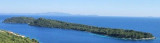
You can anchor in 10 to 5 m or moor at the dock at W side of the bay.
Good protection.

2011/05/13
Update
Jojo
Vela Luka Korcula
Uvala Vela Luka Korcula
2011-05-13
Update
Jojo
Vela Luka Korcula
Uvala Vela Luka Korcula
2011-05-13
Update
Jojo
Vela Luka Korcula
Otocic Osjak
2011-05-13
Update
Jojo
Please correct 4 m is not 4 ft
2012/01/22
Update
Vela Luka est située à l'W de l'île de Korcula au fond d'une baie large et comportant de nombreuses anses.
Les pentes environnantes descendent lentement vers la mer et sont couvertes de vignobles, oliviers, figuiers et pins.
Comme des perles dans la baie de Vela Luka, surgissent les petites îles de Proizd et Oąjak.

Vela Luka est la plus grande agglomération de l'île de Korcula. 

En approchant la baie par l'E, attention à Plicina Kriz, un haut-fond sous moins de 4 m d'eau, situé à près de 0,2 NM au NE de la pointe E.

On peut mouiller par 10 à 5 m ou s'amarrer au quai du côté W de la baie.

Bonne protection.

2011/05/21
Update
Jojo
Ebook

Dubrovačko-neretvanska županija (Dubrovnik–Neretva

  • 138 sites
  • 228 photos
  • publication date: 9 Jul 2023
  • .pdf file size: 74 Mb
Ebook

Dalmacija (Dalmatie)

  • 542 sites
  • 910 photos
  • publication date: 9 Jul 2023
  • .pdf file size: 302 Mb
Share your comments or photos on "Vela Luka Korcula"

Sites around Vela Luka Korcula

Flying distances - Direct line

Uvala Vela Luka Korcula

1.8nm
263°
Zaljev Vela Luka is a large bay on the E O. Korcula. Many coves occupy the bay. At the bottom of it is the port of Vela Luka, an active and well sheltered.
Easily identifiable by day or night, you can enter this great bay in all weather.
Dangers in the general approach are the ...
21 May 11
Jojo

Starogradski Zaljev Hvar

15nm
332°
Starogradski is a large deep bay, open to the NW, which houses the city and the port of Stari Grad on its SE end.
There are several bays, including its N side, where it is possible to anchor. On the other side there is an anchor in front Gradisce.
31 May 11
Jojo

Otok Scedro Hvar

7.6nm
354°
Otok Scedro lies 3 miles E of Hridi Lukavci.
It is 2,7 km off the S coast of island of Hvar.The inhabited island is elevated at each end and slopes towards the sea in the middle. Its coastline includes many coves where you can get wet. The two most popular are Uvala Uvala Lovisce ...
25 May 11
Jojo

Otoci Pakleni

18nm
309°
Plakeni islands, or Cursed Islands, are located at the W and S of Hvar town.

The islands are rocky, covered with bushes and trees. They are usually deserted, except in summer.
They offer many choices of moorings sheltered and there is a marina Palmizana.The islands'name ...
26 May 11
Jojo

Otocic Zvirinovik Korcula

3.1nm
168°
Zvirinovikis a small uninhabited island located S from Korcula island, in front of Karbuni hamlet.Its area is 0.405 square kilometers. It offers 4.21 km length of coast and rises to 56 m.
The island can be circumvented by N or S.
Coming from the S, attention to the island ...
20 May 11
Jojo

Otok Kopiste Lastovo

12nm
181°
L'île Kopiste appartient au groupe d'îles du parc naturel de Lastovo. Elle est située à l'W de Lastovo après O. Przba et O. Mrcara dont elle est séparée par le canal de Zaplja.
Elle est entourée de trois îlots: O. Bijelac, O. Pod Kopiste et O Crnac.
11 May 11
Jojo