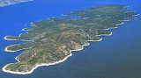
Starogradski Zaljev Hvar
15nm
339°
There are several bays, including its N side, where it is possible to anchor. On the other side there is an anchor in front Gradisce.
31 May 11
Jojo
| Latitude | Longitude | |
| DMS | --- | --- |
| DM | --- | --- |
| DD | --- | --- |

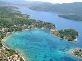
 Zaljev Vela Luka is a large bay on the E O. Korcula. Many coves occupy the bay. At the bottom of it is the port of Vela Luka, an active and well sheltered.
 Zaljev Vela Luka est une grande baie située à l'E d'O. Korcula. De nombreuses anses occupent cette baie. Au fond de celle-ci se trouve le port de Vela Luka, très actif et bien abrité.
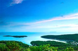
Facilement identifiable de jour comme de nuit, on peut entrer dans cette grande baie par tous temps.
Les dangers dans l'approche générale sont le rocher et haut-fond au large de Rt Velo Dance et les rochers et hauts-fonds d'O. Proizd.
Dans la baie, Otok Kamenjak (qui porte un feu et une balise) est prolongée par une zone de hauts-fonds (6 m), à 0,5 M au SW d'O. Kamenjak.
Le mieux est de passer au S de Kamenjak, puis faire route sur le feu de la pointe N de l'entrée de Vela Luka, en passant au N d'O Osjak.
Ebook | Dubrovačko-neretvanska županija (Dubrovnik–Neretva
|