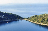
Uvala Vela Luka Korcula
3.8nm
319°
Easily identifiable by day or night, you can enter this great bay in all weather.
Dangers in the general approach are the ...
21 May 11
Jojo
| Latitude | Longitude | |
| DMS | --- | --- |
| DM | --- | --- |
| DD | --- | --- |

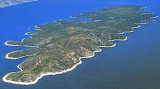
 Zvirinovikis a small uninhabited island located S from Korcula island, in front of Karbuni hamlet.Its area is 0.405 square kilometers. It offers 4.21 km length of coast and rises to 56 m.
The island can be circumvented by N or S.
Coming from the S, attention to the island to the east of the island that can be circumvented.
Coming from Grscica, can pass between the N and Korcula islands, but the channel is narrow.
It can also switch to the S O. Kosor, giving a wide berth to the area of shoal in the SE.

 Zvirinovik est une petite île inhabitée située au S de l'île Korcula, face au hameau de Karbuni.
Sa superficie est de 0,405 km².Elle offre 4,21 km de longueur de côte et culmine à 56 m.
L'île peut être contournée par le N ou le S.
En arrivant du S, attention à l'îlot à l'E de l'île que l'on peut contourner.
En arrivant de Grscica, on peut passer entre Korcula au N et les îles, mais le chenal est étroit.
On peut aussi passer au S d'O. Kosor, en donnant un large tour à la zone de haut-fond dans son SE.
Ebook | Dubrovačko-neretvanska županija (Dubrovnik–Neretva
|