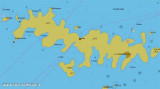
Starogradski is a large deep bay, open to the NW, which houses the city and the port of Stari Grad on its SE end. There are several bays, including its N side, where it is possible to anchor. On the other side there is an anchor in front Gradisce.
2011/05/31
Update
Jojo
Starogradski est une grande baie profonde, ouverte au NW, qui abrite la ville et le port de Stari Grad à son extrémité SE. Il y a plusieurs baie, notamment sur sa côte N, où il est possible de mouiller. De l'autre côté il y a un mouillage devant Gradisce.
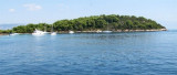
Plakeni islands, or Cursed Islands, are located at the W and S of Hvar town.
The islands are rocky, covered with bushes and trees. They are usually deserted, except in summer. They offer many choices of moorings sheltered and there is a marina Palmizana.The islands'name ...
Pakleni Kanal lies between Pakleni Otoci and Otok Hvar. It is a deep and wide channel, with access at both ends, which leads to Luka Hvar. This channel is frequented by small vessels with local knowledge and affords good shelter from the bora, although heavy squalls may be encountered. The ...
Ciovo is an island in the center of the Dalmatian archipelago. This is an area of 28.8 acres (15.3 km length, width of 3.5 km). It culminates at 218 m (Mount Rudin). O. Ciovo forms the SW side of the entrance and inner part of Kastelanski Zaliv. At East side, Ciovo is 2km from ...
The island Sveti Klement is the largest of the "Pakleni Otoci".
Its area is 5.27 square kilometers and it has 29.891 km of rocky coasts. A portion of the island, whose highest peak, Glavica, is 94 m high, is covered with scrub and pine woods. The island is surrounded by ...
Zaljev Vela Luka is a large bay on the E O. Korcula. Many coves occupy the bay. At the bottom of it is the port of Vela Luka, an active and well sheltered. Easily identifiable by day or night, you can enter this great bay in all weather. Dangers in the general approach are the ...
This large bay on the N side of Starogradski Zaljev is wide and deep. It has several coves offering safe anchorage. Entering, attention to the rock on the peak W, Mali Rati. The various parts of the bay provide every direction.


 Starogradski is a large deep bay, open to the NW, which houses the city and the port of Stari Grad on its SE end.
 Starogradski est une grande baie profonde, ouverte au NW, qui abrite la ville et le port de Stari Grad à son extrémité SE.