Otoci Pakleni

Otoci Pakleni

To precisely geolocate this site. Update if necessary.

Localisation

Characteristics

Island / Atoll

Description

Plakeni islands, or Cursed Islands, are located at the W and S of Hvar town.


The islands are rocky, covered with bushes and trees. They are usually deserted, except in summer.
They offer many choices of moorings sheltered and there is a marina Palmizana.

The islands'name comes from "Paklina" which means pine resin. It was used to seal vessels.

Beginning with W and going eastward (toward the town of Hvar) the names of islands are:
O. Vodnjak M
O. Vodnjak V
O Travna, Hr Karbuni and Hr Lengva, O. Parzanj and O. Borovac
O. Sv Klement
N of Sv Klement, O. Vlaka, Hr Baba, O. Gojca
After O. Sv Klement, O. Borovac and Planikovac, O. Marinkovac, O. Jerolim and N there O. Galisnik, O. Pokonji Dol
SW O. Sv Klement, are Hr Plocice and O. Stambedar, and W it O. Dobri.

2011/05/26
Update
Jojo
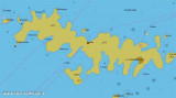
Les îles Plakeni, ou îles Maudites, sont situées à l'W et au S de la ville de Hvar.

Les îles sont rocheuses, couvertes de broussailles et d'arbres. Elles sont généralement désertes, sauf en été.

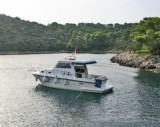
Elles offrent de nombreux choix de mouillages abrités et il y a une marina à Palmizana.

Le nom des îles vient de "Paklina" qui signifie résine de pin. Celle-ci servait à l'étanchéité des bateaux.

En commençant par l'W et en allant vers l'E (vers la ville de Hvar) le nom des îles de l'archipel sont les suivants:
O. Vodnjak M, O. Vodnjak V, O Travna, Hr Karbun et Hr Lengva, O. Parzanj et O. Borovac, O. Sv Klement, au N de Sv Klement, O.Vlaka, Hr Baba, O. Gojca
Après O. Sv Klement, O. Borovac et Planikovac, O. Marinkovac, O. Jerolim et au N de celle-ci O. Galisnik, O. Pokonji Dol
Au SW de O. Sv Klement, se trouvent Hr Plocice et O. Stambedar, et à l'W de celle-ci O. Dobri.


2011/05/26
Update
Jojo
Ebook

Splitsko-dalmatinska županija (Split-Dalmatia Coun

  • 155 sites
  • 295 photos
  • publication date: 6 Jul 2023
  • .pdf file size: 97 Mb
Ebook

Dalmacija (Dalmatie)

  • 542 sites
  • 910 photos
  • publication date: 9 Jul 2023
  • .pdf file size: 302 Mb
Share your comments or photos on "Otoci Pakleni"

Sites around Otoci Pakleni

Flying distances - Direct line

Pakleni Kanal

0.8nm
10°
Pakleni Kanal lies between Pakleni Otoci and Otok Hvar.
It is a deep and wide channel, with access at both ends, which leads to Luka Hvar.
This channel is frequented by small vessels with local knowledge and affords good shelter from the bora, although heavy squalls may be encountered.
The ...
30 May 11
Jojo

Otok Ciovo

20nm
349°
Ciovo is an island in the center of the Dalmatian archipelago. This is an area of 28.8 acres (15.3 km length, width of 3.5 km). It culminates at 218 m (Mount Rudin).
O. Ciovo forms the SW side of the entrance and inner part of Kastelanski Zaliv.
At East side, Ciovo is 2km from ...
7 Aug 11
cdg2

Starogradski Zaljev Hvar

7.8nm
76°
Starogradski is a large deep bay, open to the NW, which houses the city and the port of Stari Grad on its SE end.
There are several bays, including its N side, where it is possible to anchor. On the other side there is an anchor in front Gradisce.
31 May 11
Jojo

Otok Sveti Klement Pakleni

0.9nm
259°
The island Sveti Klement is the largest of the "Pakleni Otoci".
Its area is 5.27 square kilometers and it has 29.891 km of rocky coasts.
A portion of the island, whose highest peak, Glavica, is 94 m high, is covered with scrub and pine woods.
The island is surrounded by ...
27 May 11
Jojo

Otok Svetac (Andrija)

28nm
253°
Otok Svetac (Andrija), 305m high, lies 13 miles ESE of Otocic Jabuka and is generally steep-to. The coast of the island is rocky and reddish in color on the NW side. Its SW end is fronted by a few rocks. Hrid Kamik, a dark and jagged above-water rock, lies 0.7 mile W of the SW extremity ...
25 May 11
Jojo