Uvala Zaton

Uvala Zaton

To precisely geolocate this site. Update if necessary.

Localisation

Characteristics

Port Zaton
Mud
Mooring
Sand
Market Zaton
Restaurant sur le port
Post Zaton

Description

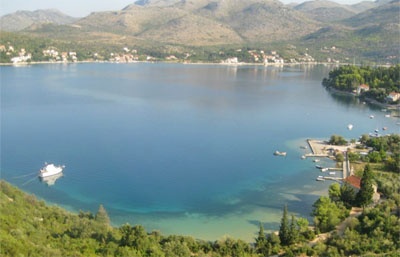
Located in a nice little sheltered inlets, Zaton offers a small port and several anchorages.
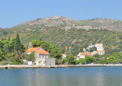
The entrance is about 1 NM NNE of otocic Daksa. The fire of Ruth Bat, W of the entrance to help identify him.
Beware of submerged rocks to the east of the port, covered by 4.5 m of water.
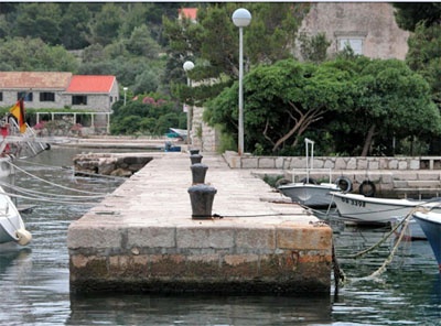
We moored along the harbor breakwater. The port is not free.
You can anchor in the NE or SE of the port, avoiding the rock that lies to the east of the port.
You can also anchor face, Stikovica by 7 m or N of the loop by 7 m.
Open to the S / SE and SW.
2011/04/15
Update
Jojo
Uvala Zaton
2011-04-15
Update
Jojo
Situé dans un agréable petit bras de mer bien abrité, Zaton offre un petit port et plusieurs mouillages.

L'entrée se trouve à environ 1 NM au NNE d'otocic Daksa. Le feu de Rt Bat, à l'W de l'entrée, aide à l'identifier.
Attention au rocher submergé à l'E du port, couvert par 4,5 m d'eau.

On s'amarre le long de la digue du port. Le port est payant.

On peut mouiller au NE ou au SE du port en évitant le rocher qui se trouve à l'E du port.

On peut mouiller aussi en face, à Stikovica par 7 m ou tout au N de l'anse par 7 m.

Ouvert au S/SE et de SW.
2011/04/15
Update
Jojo
Uvala Zaton
2011-04-15
Update
Jojo
Uvala Zaton
2011-04-15
Update
Jojo
Ebook

Dubrovačko-neretvanska županija (Dubrovnik–Neretva

  • 140 sites
  • 228 photos
  • publication date: 6 Aug 2024
  • .pdf file size: 79 Mb
Share your comments or photos on "Uvala Zaton"

Sites around Uvala Zaton

Flying distances - Direct line

Otok Sipan

7.2nm
287°
It is the largest and most populated island of the group Elafiten. It rises to 234 m at its N and a prominent hill rises 224 m NW of the SE end.
Ruda is a small island that is 0.5 M SE of the NE extremity of the island and Misnjaka, 13 m high, lies close off the NW extremity.
...
16 Apr 11
Jojo

Otok Lopud

3.8nm
265°
The island of Lopud belongs Elaphites. It is only 4.6 km2.
It has a pleasant village and some old buildings. You'll find a sandy beach.
There are two good anchorages: uvala Lopud (NW of the island), where is the village and uvala Sunj (SE of the island).
15 Apr 11
Jojo

Otok Kolocep

1.9nm
235°
Kolocep island is located two NM from Dubrovnik. This small island is part of the archipelago of islands Elafiten.
Locals also call it Kalamota. Its area is 2.35 km2.
On the island there are two villages in the two largest bays of the island: Gornje Celo and Donje Celo that ...
15 Apr 11
Jojo

Stonski Kanal

15nm
297°
Stonski Kanal, a deep inlet, indents the SE end of Poluotok Peljesac at the NW end of Kolocepski Kanal.
Its shore rises rapidly on each side and provides protection from NE and SW winds. The village of Brocej is situated on the S shore 3.8 miles within the entrance.
It is fronted ...
25 Apr 11
Jojo

Zupski Zaliv

9.1nm
125°
Zupski Zaliv is entered between Rt Sustjepan and Rt Pelegrin, 2.5 miles NW. The E and SE shores of this bay are backed by mountains, but a valley through which a river flows lies within the N shore.
Malastica, 628m high, stands 1 mile N of the bay. This hill has a somewhat sharp ...
13 Apr 11
Jojo

Rt Bat

0.3nm
159°
Rt Bat, the W entrance point of Luka Zaton, is located 1 mile NNW of Otocic Daksa.Caution.—A submarine pipeline extends 0.8 mile S from a point on the coast 0.4 mile E of Rt Petka.
A submarine cable, extends inshore along the coast between Ostri Rt and Hridi Grebeni.
Several ...
15 Apr 11
Jojo