Located N of the Bay of Vela Luka, Uvala Gradina provides good anchorage for N O. Sveti Ivan, connected to Korcula by a narrow causeway. The islet Gubesa protect the creek winds from S and SW. We can pass on either side of O and wet Gubesa by 6 m.
2011/05/21
Update
Jojo
Située au N de la baie de Vela Luka, Uvala Gradina offre un bon mouillage au N d'O. Sveti Ivan, relié à Korcula par une chaussée étroite. L'îlot Gubesa ferme la crique et la protège des vents du S et SW.
On peut passer de chaque côté d'O Gubesa et mouiller par 6 m.
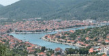
Zaljev Vela Luka is a large bay on the E O. Korcula. Many coves occupy the bay. At the bottom of it is the port of Vela Luka, an active and well sheltered. Easily identifiable by day or night, you can enter this great bay in all weather. Dangers in the general approach are the ...
Starogradski is a large deep bay, open to the NW, which houses the city and the port of Stari Grad on its SE end. There are several bays, including its N side, where it is possible to anchor. On the other side there is an anchor in front Gradisce.
Otok Scedro lies 3 miles E of Hridi Lukavci. It is 2,7 km off the S coast of island of Hvar.The inhabited island is elevated at each end and slopes towards the sea in the middle. Its coastline includes many coves where you can get wet. The two most popular are Uvala Uvala Lovisce ...
Plakeni islands, or Cursed Islands, are located at the W and S of Hvar town.
The islands are rocky, covered with bushes and trees. They are usually deserted, except in summer. They offer many choices of moorings sheltered and there is a marina Palmizana.The islands'name ...
From S of Vela Luk, that large bay is located at the end W of O. Korcula.Open to NW and W.he bay is divided into two parts. We anchored in the NE by 6 m.
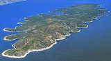
Vela Luka is located on the western side of the island
of Korcula at the bottom of a sharply cut and wide bay indented by many
coves. The surrounding slopes descend slowly to the sea and are covered
with vineyards, olive trees, fig trees and pine. Scattered like pearls
in ...


 Bonne tenue


 Located N of the Bay of Vela Luka, Uvala Gradina provides good anchorage for N O. Sveti Ivan, connected to Korcula by a narrow causeway.
 Située au N de la baie de Vela Luka, Uvala Gradina offre un bon mouillage au N d'O. Sveti Ivan, relié à Korcula par une chaussée étroite.