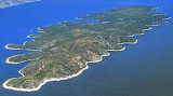
Tri Luke is a large inlet on the wouthwestern side of Korčula,
southwest of the town of Vela Luka and about 1.5 NM
east of cape Rat Velo Dance. As you can guess from the name, the inlet has
three smaller bays. Wind and waves from the southeast have free reign in the
bay, but it is well protected against all other wind directions. The three
smaller bays offer protection in all conditions.
Caution: Around the islets Pržnjak Mali andPržnjak
Veli there are shallow areas and rocks just below or just above the
waterline. Avoid this area during heavy swell and in the dark.
2011/05/20
Update
Jojo
2011-05-20
Update
Jojo
Sur le côté SW de Korcula, au SW de Vela Luka, se trouvent trois baies, à eenviron 1,5 NM à l'E du cap Rat Velo Dance. Le vent et les vagues du sud entrent dans la baie, mais elle est bien protégée contre toutes les autres vents. Les trois petites baies offrent une protection dans toutes les conditions. Attention: Autour des îlots Pržnjak Mali andPržnjak Veli il y a des zones peu profondes et les rochers juste en dessous ou juste au-dessus de l'eau. Évitez ce domaine au cours de forte houle et dans l'obscurité.
Zaljev Vela Luka is a large bay on the E O. Korcula. Many coves occupy the bay. At the bottom of it is the port of Vela Luka, an active and well sheltered. Easily identifiable by day or night, you can enter this great bay in all weather. Dangers in the general approach are the ...
Starogradski is a large deep bay, open to the NW, which houses the city and the port of Stari Grad on its SE end. There are several bays, including its N side, where it is possible to anchor. On the other side there is an anchor in front Gradisce.
Otok Scedro lies 3 miles E of Hridi Lukavci. It is 2,7 km off the S coast of island of Hvar.The inhabited island is elevated at each end and slopes towards the sea in the middle. Its coastline includes many coves where you can get wet. The two most popular are Uvala Uvala Lovisce ...
Plakeni islands, or Cursed Islands, are located at the W and S of Hvar town.
The islands are rocky, covered with bushes and trees. They are usually deserted, except in summer. They offer many choices of moorings sheltered and there is a marina Palmizana.The islands'name ...
From S of Vela Luk, that large bay is located at the end W of O. Korcula.Open to NW and W.he bay is divided into two parts. We anchored in the NE by 6 m.
L'île Kopiste appartient au groupe d'îles du parc naturel de Lastovo. Elle est située à l'W de Lastovo après O. Przba et O. Mrcara dont elle est séparée par le canal de Zaplja. Elle est entourée de trois îlots: O. Bijelac, O. Pod Kopiste et O Crnac.


 Tri Luke is a large inlet on the wouthwestern side of Korčula,
southwest of the town of Vela Luka and about 1.5 NM
east of cape Rat Velo Dance.
Tri Luke is a large inlet on the wouthwestern side of Korčula,
southwest of the town of Vela Luka and about 1.5 NM
east of cape Rat Velo Dance.
 Sur le côté SW de Korcula, au SW de Vela Luka, se trouvent trois baies, à eenviron 1,5 NM à l'E du cap Rat Velo Dance.