Approaching the S, attention to the area of shoal SE of the island, within 5 m of water. There was a rock near Cape DO U. Portoc. We anchor by m 10/12, the pier is reserved for tour boats and ferries.
2011/04/15
Update
Jojo
En approchant par le S, attention à la zone de haut-fond au SE de l'île, sous 5 m d'eau. Il y a un rocher près du cap NE d'U. Portoc.
On mouille par 10/12 m, la jetée est réservée aux bateaux d'excursion et aux Ferries.
It is the largest and most populated island of the group Elafiten. It rises to 234 m at its N and a prominent hill rises 224 m NW of the SE end. Ruda is a small island that is 0.5 M SE of the NE extremity of the island and Misnjaka, 13 m high, lies close off the NW extremity. ...
Zupski Zaliv is entered between Rt Sustjepan and Rt Pelegrin, 2.5 miles NW. The E and SE shores of this bay are backed by mountains, but a valley through which a river flows lies within the N shore. Malastica, 628m high, stands 1 mile N of the bay. This hill has a somewhat sharp ...
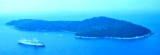
Lokrum Otok Island is a 89 m high, located S of Dubrovnik, 3 NM WNW of Rt Pelegrin, the entry point of W Zupski Zaliv. This wooded island, dark green has two peaks. Of SW it appears as two islands. The ruins of a fort located on the top N and S amounts to a monastery on the flat ...
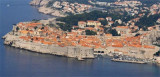
Dubrovnik enjoyed its greatest prosperity in the fifteenth and sixteenth century thanks to its fleet, the third world. There is a small port, Stara Luka, away from the ramparts, but boaters are not allowed. It is reserved for local boats and tour boats. Boaters should proceed to ...
Otocic Cavtatski Grebeni, a group of islets and above-water rocks, lies up to 2 miles W of Rt Sustjepan, on a line NW-SE parallel to the coast. Otocic Mrkan, the largest islet, is 65m high and appears dark from seaward. NW is the island Bobara. Between the two islands are ...
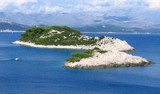
The island of Lopud belongs Elaphites. It is only 4.6 km2. It has a pleasant village and some old buildings. You'll find a sandy beach. There are two good anchorages: uvala Lopud (NW of the island), where is the village and uvala Sunj (SE of the island).


 Approaching the S, attention to the area of shoal SE of the island, within 5 m of water. There was a rock near Cape DO U. Portoc.
 En approchant par le S, attention à la zone de haut-fond au SE de l'île, sous 5 m d'eau. Il y a un rocher près du cap NE d'U. Portoc.