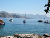
Dubrovnik enjoyed its greatest prosperity in the fifteenth and sixteenth century thanks to its fleet, the third world. There is a small port, Stara Luka, away from the ramparts, but boaters are not allowed. It is reserved for local boats and tour boats. Boaters should proceed to the port of Gruz Dubrovnik or the Marina, located in Rijeka Dubrovacka. Buses connect the two marinas in Dubrovnik. Attention it is the commercial port of Gruz is the official port of entry and not the marina. Vessels under their entry into the country must go to Gruz to obtain a cruising permit before going to the marina
2011/04/4
Update
Jojo
2011-04-04
Update
Jojo
Dubrovnik connut sa plus grande prospérité au XVème et XVIème siècle grâce à sa flotte, la troisième du monde. Il y a un petit port, Stara Luka, à l'abri des remparts, mais les plaisanciers n'y sont pas autorisés. Il est réservé aux bateaux locaux et aux bateaux d'excursion. Les plaisanciers doivent se rendre au port de Gruz ou à la Marina Dubrovnik, située dans Rijeka Dubrovacka. Des bus relient les deux marinas à Dubrovnik.
Attention, c'est le port de commerce de Gruz qui est le port d'entrée officiel et pas la marina. Les bateaux faisant leur entrée dans le pays doivent donc se rendre à Gruz pour obtenir un permis de croisière avant d'aller à la marina
It is the largest and most populated island of the group Elafiten. It rises to 234 m at its N and a prominent hill rises 224 m NW of the SE end. Ruda is a small island that is 0.5 M SE of the NE extremity of the island and Misnjaka, 13 m high, lies close off the NW extremity. ...
Zupski Zaliv is entered between Rt Sustjepan and Rt Pelegrin, 2.5 miles NW. The E and SE shores of this bay are backed by mountains, but a valley through which a river flows lies within the N shore. Malastica, 628m high, stands 1 mile N of the bay. This hill has a somewhat sharp ...
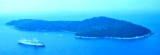
Lokrum Otok Island is a 89 m high, located S of Dubrovnik, 3 NM WNW of Rt Pelegrin, the entry point of W Zupski Zaliv. This wooded island, dark green has two peaks. Of SW it appears as two islands. The ruins of a fort located on the top N and S amounts to a monastery on the flat ...
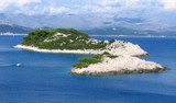
The island of Lopud belongs Elaphites. It is only 4.6 km2. It has a pleasant village and some old buildings. You'll find a sandy beach. There are two good anchorages: uvala Lopud (NW of the island), where is the village and uvala Sunj (SE of the island).
Approaching the S, attention to the area of shoal SE of the island, within 5 m of water. There was a rock near Cape DO U. Portoc. We anchor by m 10/12, the pier is reserved for tour boats and ferries.
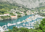
ACI marina Dubrovnik lies near Komolac about 2 Nm from the entrance to the port of Gruž and only 6 km from the old city nucleus. It is located in a small inlet (Rijeka Dubrovacka) where a river flows.Approach: After leaving Rt Kantafig starboard, back to the marina. A small advance ...


 Dubrovnik enjoyed its greatest prosperity in the fifteenth and sixteenth century thanks to its fleet, the third world. There is a small port, Stara Luka, away from the ramparts, but boaters are not allowed. It is reserved for local boats and tour boats.
 Dubrovnik connut sa plus grande prospérité au XVème et XVIème siècle grâce à sa flotte, la troisième du monde. Il y a un petit port, Stara Luka, à l'abri des remparts, mais les plaisanciers n'y sont pas autorisés. Il est réservé aux bateaux locaux et aux bateaux d'excursion.