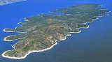
Large bay, on N coast of Hvar, between Tanki point and Zarace point, open to N and NE with veral coves where you can stop for lunch.
Navigate well around Tanki Rat (NW tip) for funding of less than 3 m beyond. The point of entry E (Rt Zarac) should not be approached too closely either. Anchor by 6 m. The bay is sheltered from all winds except N and NE.
Smaller yachts can berth alongside
the pier on the E coast of
the cove. The best anchorage
is in its SE part.
2011/06/2
Update
Jojo
2011-06-02
Update
Jojo
Grande baie, sur la côte N de Hvar, entre Tanki Rat et Rt Zarace, ouverte au N et au NE avec plusieurs anses où il est possible de s'arrêter pour déjeuner.
Donner un large tour à Tanki Rat (pointe au NW) car des fonds de moins de 3 m la débordent. La pointe E de l'entrée (Rt Zarace) ne doit pas être approchée de trop près non plus.
On mouille par 6 m.
La baie est abrité de tous vents sauf ceux de N et NE.
Les petits bateaux peuvent accoster à la jetée sur la côte E de l'anse. Le meilleur point de mouillage est dans la partie sud de la baie.
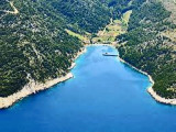
Starogradski is a large deep bay, open to the NW, which houses the city and the port of Stari Grad on its SE end. There are several bays, including its N side, where it is possible to anchor. On the other side there is an anchor in front Gradisce.
Plakeni islands, or Cursed Islands, are located at the W and S of Hvar town.
The islands are rocky, covered with bushes and trees. They are usually deserted, except in summer. They offer many choices of moorings sheltered and there is a marina Palmizana.The islands'name ...
Otok Scedro lies 3 miles E of Hridi Lukavci. It is 2,7 km off the S coast of island of Hvar.The inhabited island is elevated at each end and slopes towards the sea in the middle. Its coastline includes many coves where you can get wet. The two most popular are Uvala Uvala Lovisce ...
Zaljev Vela Luka is a large bay on the E O. Korcula. Many coves occupy the bay. At the bottom of it is the port of Vela Luka, an active and well sheltered. Easily identifiable by day or night, you can enter this great bay in all weather. Dangers in the general approach are the ...
Around 5 NM E of Jelsa is the spectacular inlet of Vela Stiniva. This high sided bay measures approximately 100 metres in width and runs about 300 metres south between towering cliffs. At its south end is a narrow pebble beach, which is clean and usually
quite. In front of this on ...
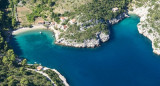
Mala Stiniva Bay is famous for its picturesque cliffs which fall sheer into the sea is composed of two coves separated by a rock. We anchored for a lunch stop in this beautiful setting.


 Large bay, on N coast of Hvar, between Tanki point and Zarace point, open to N and NE with veral coves where you can stop for lunch.
 Grande baie, sur la côte N de Hvar, entre Tanki Rat et Rt Zarace, ouverte au N et au NE avec plusieurs anses où il est possible de s'arrêter pour déjeuner.