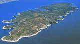
Starogradski Zaljev Hvar
11nm
281°
There are several bays, including its N side, where it is possible to anchor. On the other side there is an anchor in front Gradisce.
31 May 11
Jojo
| Latitude | Longitude | |
| DMS | --- | --- |
| DM | --- | --- |
| DD | --- | --- |


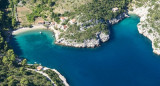
 Around 5 NM E of Jelsa is the spectacular inlet of Vela Stiniva. This high sided bay measures approximately 100 metres in width and runs about 300 metres south between towering cliffs. At its south end is a narrow pebble beach, which is clean and usually
quite. In front of this on the east side of the bay is a short concrete
jetty that is usually occupied by several large local fishing boats.
Around 5 NM E of Jelsa is the spectacular inlet of Vela Stiniva. This high sided bay measures approximately 100 metres in width and runs about 300 metres south between towering cliffs. At its south end is a narrow pebble beach, which is clean and usually
quite. In front of this on the east side of the bay is a short concrete
jetty that is usually occupied by several large local fishing boats.The bay is an idyllic spot and great for a lunch stop, but is exposed to winds from the North-west, North and North-east, and given the confines of its width may be uncomfortable or dangerous in the wrong weather.
Anchor around halfway down its length in 10-20 metres of water or closer in near the pier in 4-7 metres of water. Those intending to stay for any extended period should consider a line ashore and there four stone bollards on the shore and a platform on the west side of the inlet.

 A environ 5 NM à l'E de Jelsa se trouve la baie spectaculaire de Vela Stiniva. Cette baie, entourée de falaises abruptes, mesure environ 100 mètres de large et s'étend sur environ 300 mètres au sud entre les falaises. A son extrémité sud se trouve une étroite plage de galets, propre et en général tranquille. En face de celle-ci, sur le côté E de la baie, une jetée en béton est habituellement occupée par plusieurs grands bateaux de pêche locaux.


Ebook | Splitsko-dalmatinska županija (Split-Dalmatia Coun
|
Ebook | Dalmacija (Dalmatie)
|