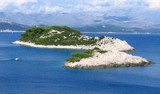
Gornje Celo is on the NE coast of Kolocep and 1.5 M SE of Rt Bat. There is a coffee and a dock near the beach. We anchor by 5 meters. Open to the N and NE.
2011/04/15
Update
Jojo
Gornje Celo se trouve sur la côte NE de Kolocep et à 1,5 M au SE de Rt Bat. Il y a un café et un quai près de la plage.
It is the largest and most populated island of the group Elafiten. It rises to 234 m at its N and a prominent hill rises 224 m NW of the SE end. Ruda is a small island that is 0.5 M SE of the NE extremity of the island and Misnjaka, 13 m high, lies close off the NW extremity. ...
The island of Lopud belongs Elaphites. It is only 4.6 km2. It has a pleasant village and some old buildings. You'll find a sandy beach. There are two good anchorages: uvala Lopud (NW of the island), where is the village and uvala Sunj (SE of the island).
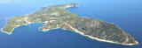
Kolocep island is located two NM from Dubrovnik. This small island is part of the archipelago of islands Elafiten. Locals also call it Kalamota. Its area is 2.35 km2. On the island there are two villages in the two largest bays of the island: Gornje Celo and Donje Celo that ...
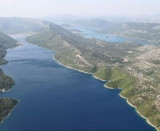
Stonski Kanal, a deep inlet, indents the SE end of Poluotok Peljesac at the NW end of Kolocepski Kanal. Its shore rises rapidly on each side and provides protection from NE and SW winds. The village of Brocej is situated on the S shore 3.8 miles within the entrance. It is fronted ...
Zupski Zaliv is entered between Rt Sustjepan and Rt Pelegrin, 2.5 miles NW. The E and SE shores of this bay are backed by mountains, but a valley through which a river flows lies within the N shore. Malastica, 628m high, stands 1 mile N of the bay. This hill has a somewhat sharp ...
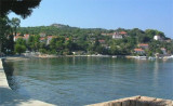
Located on the NW coast of Kolocep this bay is about 4.5 M NW Gruz. Bordered by a small village is a good anchorage for the night. A jetty is located on the E side of the bay, it can be used at night, the day it is reserved for tour boats. We anchor with 4 to 10 m. Open to the NW.


 café/bar
 Gornje Celo is on the NE coast of Kolocep and 1.5 M SE of Rt Bat. There is a coffee and a dock near the beach.
 Gornje Celo se trouve sur la côte NE de Kolocep et à 1,5 M au SE de Rt Bat. Il y a un café et un quai près de la plage.