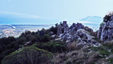
Murtas tower, stands 7 miles S of Torre San Giovanni di Sarrala, fortification of the Kingdom of Sardinia, is located on a hill overlooking the beautiful beach of Murtas. The tower has the characteristic shape of a truncated cone with different openings and dome. It was built between 1792 and 1794 to act as lookout and defense.
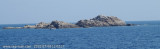
Some important red rocks above water are close E to her.
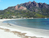
The Beach Murtas or beach Quirra is located in a military zone, which does not make it freely accessible throughout the year, but it is generally available for most of the summer..
2012/10/12
Update
Joëlle
2010:07:08 11:08:02
2012-10-12
Update
Joëlle
La tour de Murtas, à 7 MN au S de la tour S. Giovanni di Sarrala, fortification du règne de sardaigne, se trouve sur une colline surplombant la magnifique plage de Murtas. La tour a la forme caractéristique d'un cône avec des ouvertures différentes et un dôme. Il a été construit entre 1792 et 1794 pour servir de guet et de défense.
Certaines importantes roches rouges immergées se trouvent près d'elle, sur le côté E.
La plage de Murtas ou la plage Quirra est située dans une zone militaire, ce qui ne permet pas son accessibilité toute l'année, mais elle est généralement accessible pendant presque toute la période estivale.
2012/10/12
Update
Joëlle
2010:07:08 11:07:39
2012-10-12
Update
Joëlle
La Torre di Murtas, 7MN S da Torre S. Giovanni di Sarrala, fortificazione del Regno di Sardegna, si trova
su un’altura che domina la bellissima spiaggia di Murtas. La torre
presenta la caratteristica forma tronco conica con diverse aperture e
volta a cupola. Venne costruita fra il 1792 e il 1794 con funzioni di
avvistamento e difesa.
Alcuni importanti rocce rossastre sopra acqua si trovano E vicino da ella.
La Spiaggia di Murtas o spiaggia di Quirra si trova in una zona
militare, cosa che non la rende liberamente accessibile in ogni parte
dell’anno, ma la spiaggia è generalmente accessibile per quasi tutto il periodo estivo.
Cala di Murtas, also also known under the name of cove Quirra, bordered by a long sandy beach, lies between the tower and Cape S. Lorenzo. The cove is dominated by the ruins of the castle Quirra which stood on 296 m high hill.
The islet di Quirra (scoglio di Murtas) is located in front of Quirra castle, between Murtas tower and S. Lorenzo cape. It is 12 m high and is surrounded by smaller rocks. It is 12 NM SSE of Murtas tower and 1 NM offshore.From the NNE, this islet appears reddish with a whitish top.A ...
San Lorenzo cape is identified by the round tower that Stands at 184 m. It is dark and rocky.From the cape, the coast, for a distance of 3 miles to the S, is backed close inland by a chain of hills with flattened conical summits. This stretch of the coast is fringed with shoals and ...
Between Capo Bellavista and Capo Sferracavallo, 13 miles S, the coast alternates in high rocky stretches and low, sandy, and marshy stretches. The coast between Torre di Porto Corallo and Capo Ferrato is low, sandy, and backed by salt water lagoons. It is fringed with shoals and ...
Beautiful bay whose white beach named from the wide mouth of the river that flows into it. It is 1 NM S capo Sferracavallo.Ancorage during good weather, sheltered of W winds.


 Murtas tower, stands 7 miles S of Torre San Giovanni di Sarrala, fortification of the Kingdom of Sardinia, is located on a hill overlooking the beautiful beach of Murtas. The tower has the characteristic shape of a truncated cone with different openings and dome. It was built between 1792 and 1794 to act as lookout and defense.
")
 La tour de Murtas, à 7 MN au S de la tour S. Giovanni di Sarrala, fortification du règne de sardaigne, se trouve sur une colline surplombant la magnifique plage de Murtas. La tour a la forme caractéristique d'un cône avec des ouvertures différentes et un dôme. Il a été construit entre 1792 et 1794 pour servir de guet et de défense.
")
 La Torre di Murtas, 7MN S da Torre S. Giovanni di Sarrala, fortificazione del Regno di Sardegna, si trova
su un’altura che domina la bellissima spiaggia di Murtas. La torre
presenta la caratteristica forma tronco conica con diverse aperture e
volta a cupola. Venne costruita fra il 1792 e il 1794 con funzioni di
avvistamento e difesa.
La Torre di Murtas, 7MN S da Torre S. Giovanni di Sarrala, fortificazione del Regno di Sardegna, si trova
su un’altura che domina la bellissima spiaggia di Murtas. La torre
presenta la caratteristica forma tronco conica con diverse aperture e
volta a cupola. Venne costruita fra il 1792 e il 1794 con funzioni di
avvistamento e difesa.