Beautiful bay whose white beach named from the wide mouth of the river that flows into it. It is 1 NM S capo Sferracavallo.
Ancorage during good weather, sheltered of W winds.
2012/10/12
Update
Joëlle
Belle baie dont la plage de sable blanc prend le nom de l'embouchure de la rivière qui se jette dans la mer. Elle est à 1MN au sud du Capo Sferracavallo.
Mouillage de beau temps pour s'abriter de l'W.
2012/10/12
Update
Joëlle
Bella baia il cui bianco arenile prende il nome dall'ampia foce del torrente che in essa sbocca. E'1 MN S da Capo Sferracavallo.
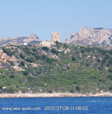
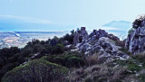
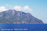
Sferracavallo cape is located N just after Coccorrocci beach and immediatly before Fosi Manna beach, to S.Capo Sferracavallo is a rocky promontory, covered with low vegetation. It is dominated by the tip Cartuccedu (598 m high). Ferru Mount (875 m high) is 2NM NW Cape and it is also ...
Gulf di Tortoli is entered between Isola dell’Ogliastra and Capo Bellavista, marked by a light, 2.5 miles S. Winds from the NW and NE quadrants come up suddenly and blow with extreme violence in this vicinity. They may last for 4 or 5 days and are preceded by whitish clouds ...
Murtas tower, stands 7 miles S of Torre San Giovanni di Sarrala, fortification of the Kingdom of Sardinia, is located on a hill overlooking the beautiful beach of Murtas. The tower has the characteristic shape of a truncated cone with different openings and dome. It was built between ...
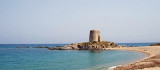
The Bari tower, remarkable, is an ancient medieval tower on the east coast of Sardinia, in the province of Ogliastra, 4.5 km from the city of Bari Sardo.
Bari Tower stands on a rocky promontory, advancing towards the sea, and is bordered by a sandy beach, called Bari beach.The ...
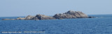
The islet di Quirra (scoglio di Murtas) is located in front of Quirra castle, between Murtas tower and S. Lorenzo cape. It is 12 m high and is surrounded by smaller rocks. It is 12 NM SSE of Murtas tower and 1 NM offshore.From the NNE, this islet appears reddish with a whitish top.A ...
Cala di Murtas, also also known under the name of cove Quirra, bordered by a long sandy beach, lies between the tower and Cape S. Lorenzo. The cove is dominated by the ruins of the castle Quirra which stood on 296 m high hill.


 Beautiful bay whose white beach named from the wide mouth of the river that flows into it. It is 1 NM S capo Sferracavallo.
 Belle baie dont la plage de sable blanc prend le nom de l'embouchure de la rivière qui se jette dans la mer. Elle est à 1MN au sud du Capo Sferracavallo.
 Bella baia il cui bianco arenile prende il nome dall'ampia foce del torrente che in essa sbocca. E'1 MN S da Capo Sferracavallo.
")
")